New Indian-Chennai News + more

Members Login
Username 
 
Password 
    Remember Me  
Post Info TOPIC: Semmozhi Tamil- Ancient Archaeology findings


Guru

Status: Offline
Posts: 24603
Date:
RE: Semmozhi Tamil- Ancient Archaeology findings
Permalink  


Senchi samanap padukgai12_03_2012_011_007


__________________


Guru

Status: Offline
Posts: 24603
Date:
Permalink  
 

Pc0051000


__________________


Guru

Status: Offline
Posts: 24603
Date:
Permalink  
 

Vedic-era rock memorials found near city 

D Madhavan TNN 

Sriperumbudur: For thousands of years,history remained buried under boulders near a lake in Sriperumbudur.That changed recently when a team of archaeologists excavated the site after finding signs of human activity including marks that appeared to have been made by stone tools.
The archaeologists discovered that the boulders were a chain of animal-shaped memorials from the early Iron Age,dating back to around 1,000 BC.On Saturday,a team of experts from the Archaeological Survey of India visited the site and took samples as evidence.
The discovery was made on an elevated part of a lake in Vadamangalam near Sriperumbudur.The biggest of the memorials is a tortoise-shaped monument around 35 metres long and 20 metres wide.
The archaeologists also found several other memorials in animal forms and unearthed buried pots a few hundred metres from the tortoise-shaped monument.One of the buried pots contained a part of a corroded cleaver,a chisel and three smaller pots containing grains and another pot with some liquid.Pot burials,the archaeologists said,are common across ancient cultures that believed in life after death.The objects are placed with the body so the person could use them in the next world.
The presence of iron tools was not unexpected because last year we discovered a large iron smelting unit at Balanallur,some 4 km from here.What excited us were the animalshaped memorials, said geoarchaeologist S Rama Krishna Pisipaty.Archaeologists said the findings are the first evidence of animal-shaped memorials dating back to Iron Age in the country.Memorials from this period discovered earlier were human-shaped or stone circles.Most of the memorials are tortoise and reptile-shaped,exhibiting the influence of later Vedic period.The later Vedic period was succeeded by Early Iron Age.
The memorials could also have been built for the leader of atribe,the archaeologists said.
As the area has been extensively used by the sand mining industry,the ASI last week erected a board declaring the site as a monument of national importance under the Ancient Monuments and Archaeological Sites and Remains Act of 1958 and 2010.
madhavan.d@timesgroup.com

Pc0051000.jpg 
TALES FROM PAST: Archaeologists found animal-shaped memorials dating back to 1,000 BC near a lake in Sriperumbudur 


__________________


Guru

Status: Offline
Posts: 24603
Date:
Permalink  
 

சோழர் கால இந்துக்கோயில் சிதைவுகள் இந்தோனேசியாவில் கண்டுபிடிப்பு! (காணொளி)

 
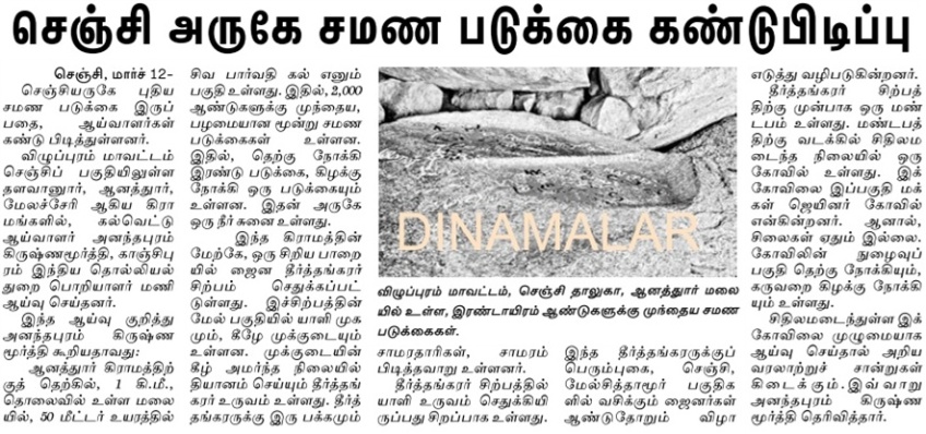
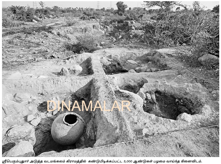
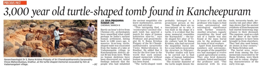
சோழர் காலத்துக்கு உரிய சைவ ஆலயம் ஒன்றின் சிதைவுகள் அகழ்வு ஆராய்ச்சி நிபுணர்களால் இந்தோனேசியாவில் கண்டு பிடிக்கப்பட்டுள்ளதாக தகவல்கள் வெளியாகியுள்ளன. 
இந்த ஆலயம் 1000 ஆண்டுகளுக்கு மேல் பழைமையானது என அறியப்படுகிறது.

http://www.youtube.com/watch?feature=player_detailpage&v=Mncl75e7THM

சிவபெருமான், விநாயகர் ஆகியோரின் சிலைகள் கண்டெடுக்கப்பட்டுள்ளதாக சர்வதேச செய்திகள் தெரிவிக்கின்றன. 

இந்த ஆலயத்தை ஒத்த ஆலயங்கள் இதற்கு முன்னர் கண்டு பிடிக்கப்பட்டு இருக்கவில்லை. 

இதனால் இது மிகவும் முக்கியத்துவம் வாய்ந்தது என நிபுணர்கள் விளக்கம் தருகின்றார்கள்.


-- Edited by Admin on Sunday 11th of March 2012 05:52:25 AM

__________________


Guru

Status: Offline
Posts: 24603
Date:
Permalink  
 

09_03_2012_010_025_001

SRIPERUMPUDUR 09_03_2012_010_026


__________________


Guru

Status: Offline
Posts: 24603
Date:
Permalink  
 

Finding Plant Domestication in the Indian Subcontinent -- Dorian Q Fuller


Listen to this article. Powered by Odiogo.com


Finding Plant Domestication in the Indian Subcontinent
 
Dorian Q Fuller
Current Anthropology , Vol. 52, No. S4, The Origins of Agriculture: New Data, New Ideas (October 2011), pp. S347-S362
Article DOI: 10.1086/658900
Article Stable URL: http://www.jstor.org/stable/10.1086/658900

FINDING PLANT DOMESTICATION IN THE INDIAN SUBCONTINENT

Dorian Q Fuller  
Dorian Q Fuller is Reader in Archaeobotany, Institute of Archaeology, University College London (31-34 Gordon Square, London WC1H 0PY, United Kingdom [d.fuller@ucl.ac.uk]).
Recent research indicates that cultivation may have begun in as many as five regions of India before the introduction of exogenous crops and cultivation systems: South India, Orissa, the Middle Ganges, Saurashtra, and the Himalayan foothills of the Punjab region. These potential centers of crop origin have been triangulated from data on the biogeography of wild progenitors and a growing archaeobotanical database. Nevertheless, none of these centers provide unambiguous evidence for local domestication or evidence that domestication occurred entirely in the absence of introduced crops and food-production systems. One of the major lacunae is archaeobotanical evidence from hunter-gatherer sites or evidence of the transition to initial cultivation. In addition, documentation of the morphological changes accompanying domestication is available for only a few species. This paper reviews the arguments for local domestication in each of these five regions, paying particular attention to data that might document domestication processes. But an alternative hypothesis for several regions also can be considered in which agriculture arose as a result of secondary domestications of local species after an initial introduction of farming from outside. On the basis of these alternative working hypotheses, research priorities are identified for resolving these issues.
This paper was submitted 13 XI 09, accepted 09 XII 10, and electronically published 21 IX 11.
CA+ Online-Only Material: Supplement A

Introduction: Multiple and Overlooked South Asian Centers of Origin

Jump To Section...
Almost everywhere on earth, hunter-gatherers of prehistory have at some time given way to farmers or given up their bows for ploughs. In archaeological research, however, greater efforts have been expended on investigating the origins of agriculture in those few world regions that have long been accepted as having been likely “centers of origin” (see Harlan 1971; Harris 1990). However, as research into agricultural origins has tended to focus on accepted centers of origin with a shortage of research on other regions, this has meant that it is difficult to assess local origins of agriculture whether by introduction or local evolution. Such blanks on the map of research in turn help to reinforce the sense that there were very few widely spaced centers of origin. One of these areas that has long been a blank on maps of early agriculture is the Indian Subcontinent, and this paper reviews recent empirical research that indicates local domestication processes.
...http://bharatkalyan97.blogspot.in/2012/03/finding-plant-domestication-in-indian.html


__________________


Guru

Status: Offline
Posts: 24603
Date:
Permalink  
 

Trefoil as an Indian hieroglyph: association with veneration of ancestors, sacredness (Kalyanaraman, March 10, 2012)


Listen to this article. Powered by Odiogo.com

Thanks to Carlos Aramayo for the insights on links with Egyptian hieroglyphs. For a detailed discussion of Indian hieroglyphs from circa 3500 BCE, see:http://tinyurl.com/7rbcer2 
 
Abstract

Sacredness connoted by the temple-priest explains the occurrence of the trefoil glyph on the two bases discovered in Mohenjo-daro, for holding śivalinga. Veneration of pitr-s (ancestors) is an ancient Indian tradition.

Use of ‘trefoil’ glyph is seen in Egyptian hieroglyphs, in Uruk and in Indus artifacts.

1)     Heifer with trefoil inlays, Uruk (W.16017) c. 3000 BCE; shell mass with inlays of lapis lazuli, 5.3 cm long. Vorderasiatisches Museum, Berlin; cf. Parpola, 1994, p. 213.

2)     Trefoil decorated bull; traces of red pigment remain inside the trefoils. Steatite statue fragment. Mohenjo-daro (Sd 767). After Ardeleanu-Jansen, 1989: 196, fig. 1; cf.  Parpola, 1994, p. 213. Trefoils painted on steatite beads. Harappa (After Vats. Pl. CXXXIII, Fig. 2)

4)Trefoils Painted On Steatite Beads, Harappa.

5) Trefoil on the shawl of the priest. Mohenjodaro. The discovery of the King Priest acclaimed by Sir John Marshall as “the finest piece of statuary that has been found at Moenjodaro….draped in an elaborate shawl with corded or rolled over edge, worn over the left shoulder and under the right arm. This shawl is decorated all over with a design of trefoils in relief interspersed occasionally with small circles, the interiors of which are filled with a red pigment “. Gold fillet with ‘standard device’ hieroglyph.

Glyph ‘hole’: pottar, பொத்தல் pottal, n. < id. [Ka.poṭṭare, Ma. pottu, Tu.potre.] trika, a group of three (Skt.) The occurrence of a three-fold depiction on a trefoil may thus be a phonetic determinant, a suffix to potṛ  as in potṛka.

Rebus reading of the hieroglyph: potti ‘temple-priest’ (Ma.)  potR `" Purifier "'N. of one of the 16 officiating priests at a sacrifice (the assistant of the Brahman), यज्ञस्यशोधयिट्रि (Vedic)

...

 
Conclusion


The trefoil is a hieroglyph read rebus. It connotes potr(i). Orthographically, it consists of pot ‘hole’ + tr(i) ‘three’ and hence depicted as three circles with holes combined into a shape of trefoil.

pot ‘young animal’; hence, depiction of trefoil on the body of a young calf. pottia ‘wearing cloth’; hence, depiction of trefoil on the shawl shown over the shoulder and breast of the ‘priest’ statuette. In a metallurgical context, pot ‘jeweller’s polishing stone’. Hence, the depiction of ‘dotted circles’ on many Indus writing corpora objects, for example, surrounding a fire-altar used for melting metals or heating crucibles.

Rebus reading is: potri ‘priest’; poTri ‘worship, venerate’. Language is Meluhha (Mleccha) an integral component of Indian sprachbund (linguistic area or language union). The trefoil is decoded and read as: potr(i).

S. Kalyanaraman, Ph.D., Sarasvati Research Center, Kalyan97@gmail.com March 10, 2012 (Paper presented at Buffalo TAG 2012 is the fifth meeting of TAG-USA, May 18-19, 2012 Open, General Session http://www.cas.buffalo.edu/tag2012/program.shtml)

Read on...http://www.docstoc.com/docs/115863006/Trefoil-as-an-Indian-hieroglyph-association-with-veneration-of-ancestors-sacredness-(March-10-2012)


__________________


Guru

Status: Offline
Posts: 24603
Date:
Permalink  
 

Epigraphic and non-prejudiced approaches to Indus writing


Listen to this article. Powered by Odiogo.com


March 9, 2012

As I read through Bryan K. Wells, 2011, Epigraphic approaches to Indus writing, Oxford and Oakville, Oxbow Books, some disturbing points emerge, related to academic prejudices in adjudicating a student’s contributions.

In the Foreword to the book, C.C. Lamberg-Karlovsky, makes some incisive observations and comments on how Bryan’s doctoral dissertation was dealt with in the academic setting of Harvard University: “Bryan Wells…came to Harvard as a graduate student intent on continuing his study of the Indus Civilization and its script…He was, and remains, committed to the idea that the Indus script represents writing and its decipherment will lead to an understanding of its texts and language. He did not think that at Harvard his dedication to this goal would meet with resistance. It did. This volume is a substantially revised edition of his doctoral dissertation. Bryan’s dissertation committee consisted  of myself as Chair and Dr. Richard Meadow and Professor Michael Witzel. A near final drft of his dissertation was rejected by Meadow and Witzel. Bryan was required to return from Germany to confront and ostensibly to correct and address its shortcomings. The basic problem was tht Profesor Witzel, influenced by Steve Farmer, had concluded that the Indus script was neither writing nor representative of language. (See ‘The Collapse of the Indus Script Thesis: The Myth of Literate Harappan Civilization’ by Steve Farmer, Richard Sproat and Michael Witzel, 2004, http://www.safarmer.com/downloads
Steve Farmer believes the Indus signs to be magical symbols.) In light of Professor Witzel’s strong commitment to the non-writing nature of the Indus script Bryan’s effort was deemed spurious and unacceptable. Richard Meadow, less strident in his view as to the nature of the Indus script, nevertheless advised Bryan to ‘tone down’ his view that the Indus represented ‘writing’. Approximately six weeks were spent as Professor Witzel balked at any mention of the Indus being a script and having a logo-syllabic nature. He insisted that Bryan sub statute the word ‘marks’ or ‘symbols’ for script. He was initially in opposition to the entire thesis. A Professor’s opinion, which, in this case is a minority view within the profession, should never be used to impose or prevent an alternative hypothesis from being addressed by a Ph.D. candidate. It was not as if Bryan was addressing an untenable, absurd hypothesis. He was to spend weeks of uncertainty, anxiety, and, in a state of near depression he puzzled over what to do. The consternation endured and expenses incurred effects his entire family. ” (pp. xiii-xv)

Lamberg-Karlovsky starts with a quote from Stephen Runciman: ‘In the battle between truth and prejudice, waged in the field of history books, it must be confessed that the latter usually wins.’ Referring to this quote, Lamberg-Karlovsky adds: ‘With the passing of time and considerable discussion, and contrary to the quote from Stephen Runciman, the quest for truth was to prevail over prejudice. Perhaps, in the context of the confrontation between a contingent of a dissertation committee and a doctoral candidate one may recall the more positive optimism voiced by John Milton in Areopagitica (1644): “Where there is much desire to learn, there of necessity will be much arguing, much writing, many opinions; for opinion in good men is knowledge in the making.” After several meetings of the dissertation committee, opinions gave way to reason.’

I can well understand the agony Bryan Wells should have gone through in his career in Harvard University as a doctoral candidate contending with prejudice of the arbiters of his thesis.

Anyway, congratulations to Bryan for the book he has just brought out. It is brilliantly presented with a detailed exposition of the use of 958 signs in the corpora of Indus inscriptions. These 958 signs constituting his sign list are presented in Figure 3.9 and in an Appendix titled 'Detail description of sign record'. He makes no claim of decipherment but documents that the number of singletons in the Mesopotamian Proto-Cuneiform are almost identical to those of the Indus script, thus refuting the Witzel-Farmer duo’s prejudiced opinion.

The work of Bryan is a significant contribution to resolving the code of the Indus script as a writing system.  Indus script is a phrase which has come to stay in the deliberations related to the civilization and there is no reason why Bryan should replace the word ‘script’ with ‘marks’ or ‘symbols’.

“Chapter 6. Indus Language…PDr (Proto-Dravidian) seems a poor fit to the morphology of Indus words…It is impossible to identify the Indus language with the data at hand, but the list can be narrowed to PM or X…The major conclusion of this chapter is that of the candidate languages considered, only Proto-Munda, Para-Munda and X cannot be eliminated from consideration. Proto-Munda and Para-Munda because the patterns of word construction are similar to those of the Indus script, and X because nothing is known about it other than words that arrive in the modern Indo-Aryan languages in addition to a few words in the Rg Veda. The elimination of the PDr from consideration is a major-step. Future research can then be focused on the reconstruction of Proto-Munda and Para-Munda and its comparison to the Indus texts and on the analysis of the words from Para-Munda and Language X.” (pp.60-61)

I have used the phrase Indian Hieroglyphs to declare Indus Script as perhaps the earliest writing system invented to complement the metallurgical inventions of the bronze-age. Many words read rebus to denote the hieroglyphs are words attested in Munda language: e.g., ranku ‘liquid measure’; ranku ‘antelope’. Rebus: ranku 'tin'.

There  is another  fact  to  which  I  shall  allude  before quitting this subject of academic prejudices or opinioated academics (I should be careful to avoid any prejudice which can be caused by my own work on decrypting the code of the writing system which may not agree with Bryan's observations).

Let me cite from Alex Burnes: “Arrian  mentions  a  nation  on  the  Indus,  called "Sangada or Saranga," and  d'Anville has supposed the country of  the Sangada to  be  the  same  as  the  modern "Sangada, or country of  the Sangarians,” whose  modern capital,  according to  Rennell, is Noanagar, on  the  south  coast  of  the gulf of  Cutch,  and  who, further coinciding with  d'Anville, conceives  that  the "Sangarians must  have  first  removed  from  the western  to  the  eastern side  of  the  Indus,  and  afterwards  must  have  also  crossed  the gulf of  Cutch."  In  the province of  Cutch,  and  about thirty,  miles  eastward  of  the  Pharrdn  river  there  is  a town  on  the  sea-coast,  called  Jacow, inhabited chiefly  by a  race  of people, called Sungars, who  have  a  well-founded  tradition  that they came  from  the  west,  and  in Alexander's time they were perhaps westward  of  the  Indus,  and  the  same people whom  Nearchus mentions  to  have  encountered  the Macedonian  hero  on  his  road  to Gedrosia,  between  the rivers  Indus  and  Arabias.”  (Memoir on the Eastern Branch of the River Indus, Giving an Account of the Alterations Produced on It by an Earthquake, Also a Theory of the Formation of the Runn, and Some Conjectures on the Route of Alexander the Great; Drawn up in the Years 1827-1828, Lieutenant Alex Burnes, Transactions of the Royal Asiatic Society of Great Britain and Ireland, Vol. 3, No. 3 (1834), p.583)


koli, baria, sangada (Indian Hieroglyphs and rebus readings: kol, tiger; badhi, rhinoceros; sangada, lathe; rebus readings: smith, carpenter, furnace/lathe)

The Kolis of Gujarat have two sub-divisions, the Patanwadias and Talpadias. Among the Talpadias, there are several sub-divisions, the main ones being the Baria, Khant, Pateliya, Kotwal and Pagi. As Barias have the high status, the entire Talpadia Koli community have adopted the name Baria. The Baria are a Hindu found in the state of Gujarat in India. They are also known as Baria Patel. They are a sub-group within the Koli community, although they now claim a Rajput origin. They get their name from the town of Devgadh Baria, which was a stronghold of the tribe. The community now deny their Koli origin, and claim to be Rajputs. They speak Gujarati. The Baria consist of a number of clans, the main ones being the Baria proper, the Patel, Pagi, Damor, Khant, Parmar, Pandor, Sangada, Chauhan and Maliwad. ( People of India Gujarat Volume XXII Part One edited by R.B Lal, S.V Padmanabham & A Mohideen page 128 to 132 Popular Prakashan).

On demographics, the Encyclopædia Britannica states: "In the early 20st century the Kolis constituted about 20 percent of the population of Gujarat, nearly 10 percent of the population of Uttar Pradesh and Rajasthan, and from 2 to 5 percent of the populations of Bengal  and Orissa and Maharashtra."

Adding a comment on the Indus language, my opinion (prejudice?) can be reiterated to promote further deliberations.

The lexemes used for rebus readings of the hieroglyphs are attested in the languages of the Indian linguistic area (sprachbund). These glosses can be gleaned from the multi-lingual lexicon of over 25 languages constructed with over 8000 semantic clusters as Indian Lexicon.
S. Kalyanaraman, Ph.D.
Sarasvati Research Center
Kalyan97@gmail.com


PS: Bryan Wells' earlier graduate thesis may be read here. (Dept. of Archaeology, Calgary, Alberta, 1998) https://dspace.ucalgary.ca/bitstream/1880/25900/1/31309Wells.pdf


See also: http://groups.yahoo.com/group/indo-euro-americo-asian_list/message/23 Steve Farmer versus Bryan Wells 
http://www.timesnow.tv/Spl-Will-the-script-be-revealed-soon/videoshow/4324250.cms Spl: Will the script be revealed soon?
http://indusresearch.wikidot.com/script Singletons
http://www.user.tu-berlin.de/fuls/Homepage/indus/help_onlinedatabase.pdf Documentation of the Online Indus Writing Database 
http://www.thehindu.com/arts/history-and-culture/article44906.ece Tracking a script


__________________


Guru

Status: Offline
Posts: 24603
Date:
Permalink  
 

SRIPERUMPUDUR 09_03_2012_010_026

Sriperumpudur 3000 year old 09_03_2012_002_031


__________________


Guru

Status: Offline
Posts: 24603
Date:
Permalink  
 

CONNECTING THE DOTS 
Latvia seeks common roots in Tamil goddess Mariamma 

TIMES NEWS NETWORK 

Chennai: The pronunciation of the name,thelong blackhair and the symbolic milking of a cow are unmistakable.Although the faces and costumes do not match,there are several reasons to believe that the Tamil goddess Mariamma is the same as Latvian goddess Mara (pronounced maara ),say Latvian researchers studying cultural relationsbetween Europe andI ndia.
I was invited to a temple festival in Tiruttani,about two hours drive from Chennai.When they called out Mariammas name,it struck me.The idol and the pictures convinced me later.Latvian Maara is known to be a single woman and as the goddess of fertility, said Professor Sigma Ankrava,a research fellow at the Indian Council for Cultural Relations and head of literature and culture in the department of English studies at the University of Latvia.She was speaking at an international conference on cultural dialogue between India and Europe,organised by the University of Madras on Monday.
Having done extensive research in Indo-European cultural relations,Ankrava is convinced that Latvia shares a large part of its heritage with Aryans.Latvians,according to many historians,originated from the southern Urals.Their migration happened to the West and to the East over the Hindukush.So many cultures and traditions are similar, saysA nkrava.
She says Latvia,like other European countries,did not have a history of caste system,though in some societies like the Celtics there existed certain stratification that resembledthe varna system.
In Latvian culture there is an upper class called Bramanis whose characteristics and social behaviour resembled Brahmins of India. They were also known to be very rich,proud and a partof theupper class of the society.Now,this word stands for arrogance. WebelievethatGerman invadersexterminatedthem in the 13 th century, says Ankrava.The invaders destroyed many old places of pre-Christian worship,butthecountry is encouraging attempts to study their oldculture andtraditions.

Pc0021100.jpg 


__________________


Guru

Status: Offline
Posts: 24603
Date:
Permalink  
 

oxygen in saturn04_03_2012_010_028


__________________


Guru

Status: Offline
Posts: 24603
Date:
Permalink  
 

Mayan civil27_02_2012_016_026


__________________


Guru

Status: Offline
Posts: 24603
Date:
Permalink  
 

Nagapattinam Buddha, Nagapattinam Pagoda


Listen to this article. Powered by Odiogo.com


Published: December 25, 2011 03:01 IST | Updated: December 25, 2011 03:40 IST
 

Stunning indicators of Nagapattinam's Buddhist legacy

T. S. Subramanian
 
The seated Buddha is a masterpiece in metal with musicians playing various instruments around him. This bronze, about 52 cm tall, establishes that the Sellur Collection belongs to the Mahayana Buddhism. Photo: V. Ganesan
The Hindu The seated Buddha is a masterpiece in metal with musicians playing various instruments around him. This bronze, about 52 cm tall, establishes that the Sellur Collection belongs to the Mahayana Buddhism. Photo: V. Ganesan
45 Buddha artefacts were on display for the first time at Government Museum in Chennai
It is a Buddha sculpture in metal only 52 cm tall. But it is a masterpiece in the detail it contains.
The Buddha is seated on a throne, his right hand in the upadesa mudra and an umbrella high above his head. An “ushnisha” (flame of knowledge) is prominent on his head and the creepers around the umbrella signify the Bodhi tree. Around the Buddha, in the outer row, is a full “orchestra” — several men are playing the lute and other stringed instruments, a couple of them are playing percussion instruments like the “mridangam” and there is also a “rasika” with his hand stretched out and enjoying the music. In the inner circle are two “ganas,” four devotees, two of whom are standing and two kneeling, all with folded hands, and a pair of prancing Yalis. Four more devotees (not seen in the picture), each kneeling in a corner, bear on their shoulders the throne.
This masterpiece was among the 42 stunning Buddha bronzes and three Buddha artefacts in stone on display for the first time at the Government Museum, Egmore, Chennai, on December 21 and 22. T. Ramalingam, a farmer and son of Thambusamy Padayachi, found this priceless treasure-trove in 2004 when labourers were digging his plot to lay the foundation for his house at South Street, Sellur village, Kodavasal taluq, Tiruvarur district, Tamil Nadu. They are all datable to the 11 century C.E. to 13 century C.E. and belong to the Chola period.
The 45 artefacts form an impressive addition to the Nagapattinam Collection of 350 Buddha bronzes, which were discovered between 1856 and the 1930s at Vellipalayam and Nanayakkara Street in Nagapattinam, where Buddhism thrived in Tamil Nadu.
The Sellur artefacts range in height from 7 cm to about 52 cm. The collection includes three Maitreya figurines. Highly ornamented, the right hand in all the three is in the “abhaya mudra” and the left holds a “naga pushpa.” There are Lokesvara and Avalokitesvaras as well. (Avalokitesvara, also called Lokesvara, is a Bodhisattva — one who has nearly attained Buddhahood but prefers to serve the public, embodying the compassion of the Buddha. Maitreya is the Buddha who will appear in the world in the future). The Buddhas in stone include those in white marble and slate stone. There is a Buddha in metal, with an inscription in Tamil on the pedestal, datable to the Chola period. The script has not been read yet.
The 45 artefacts were till now in the Kodavasal taluq office. S.S. Jawahar, Commissioner of Museums, Tamil Nadu, initiated the steps to bring them to Chennai and display them to the public. “The exhibition was organised so that people will come to know what a wonderful collection of Buddha bronzes Tamil Nadu has,” R. Balasubramanian, Curator (archaeology), Government Museum, Chennai, said.
R. Nagaswamy, reputed iconographer and former Director, Tamil Nadu Archaeology Department, said the seated Buddha with musicians, followers and yalis around him was “an interesting and a very important find.” The entire Sellur Collection belonged to Mahayana Buddhism, which believed in worshipping the Buddha in form and portrayed Avalokitesvara, Lokesvara, Maitreya and others, and used more of Sanskrit, Dr. Nagaswamy explained.
Another bronze of extraordinary workmanship found in the Sellur collection is a votive stupa, about 30 cm tall. On the base of the stupa, around the four sides, are tales from the Buddha's life. On the one side is Nalagiri, the mad elephant kneeling before the Buddha on hearing his voice, and the Buddha calming it with his hand. On another side is the Buddha preaching his very first sermon, after his Enlightenment, in the Deer Park of Isipatana, now called Sarnath, near Varanasi. Below him is a Dharma Chakra, flanked by two deer and followers with folded hands. Below this panel is a standing Buddha, with an attendant holding a parasol with a tall stem above the Buddha's head. On another side is the Buddha in Maha Parinirvana, that is after his death. On the fourth side is a seated Buddha, with his right hand in “bhoomi sparisa” mudra. On top of this base is the circular “anda” and above it is the “harmika” or the tieredvimana. Lift the anda and the harmika and, lo and behold, there emerges a tiny seated Buddha.

“A rare votive stupa”

Mr. Balsubramanian called it “a rare votive stupa.” Its style and the Jataka tales sculpted on its sides had a “close affinity to the Maha Chaitya” found at Amaravathy, near Guntur, Andhra Pradesh.
“Perhaps, the Chola craftsman had visited Amaravathy before he did his piece in metal,” he surmised.
This votive stupa was another “clear-cut demonstration” that the Sellur collection belonged to Mahayana Buddhism, Dr. Nagaswamy said.
“The Sellur discoveries are definitely important and they increase our knowledge of Buddhism in Tamil Nadu,” Dr. Nagaswamy said.
The Buddha bronze, excavated at Sellur village near Kodavasal, Tiruvarur district, in Tamil Nadu in 2004, has an inscription in Tamil on its pedestal datable to the Chola period. Photo: V. Ganesan
 

The Nagapattinam pagoda


My recent references to the Nagapattinam vihara has K.R.A. Narasiah adding more information citing Noboru Karashima, Y. Subbarayulu, Dr. D. Dayalan of the Archaeological Survey of India and, long before all of them, Walter Elliot writing in the Indian Antiquary . Elliot wrote that a strange shaped masonry tower called the Chinese Pagoda was demolished in 1867. In 1846 he had had a sketch of this tower prepared and this sketch later found a place in Dayalan'sArchaeological Sites and Evidences of Maritime Buddhism in South India (my illustrations today).
Karashima, that well-known Tamil scholar, wrote in a paper in 1992 that in an exhibition in Tokyo of Rockefeller-owned artefacts he had found a bronze standing Buddha similar to ones found in Nagapattinam which are now in the Government Museum in Madras. The Nagapattinam bronzes have been dated to the 11th Century. The bronze exhibited in Japan was on a lotus-shaped pedestal and it had a Tamil inscription that Karashima read:
1. Irajendra perumpalli akkasaip perumpalli alvar-koyilukutiruvavutsavam elundarula alvar ivvalvarai elundaralavittar cirutavur nalan kunakara udaiyar.
2. Svasti sri padinen-vishayattukum akkasaikal nayakar
and translated as follows:
1. (This is) the Alvar for a festival procession of the temple of Akkasalai-Perumpalli in Rajendra Chola-Perumpalli . This Alvar was set up by Nalan-gunakara-Udaiyar of Chiruthavur .
2. Let it be auspicious! (This Alvar called) Akkasaikal-nayakar is for all the Padienvishayam .
Narasiah says that ‘Padinen vishayam' is a merchant guild and linked as it is with Akkasalai (a mint or goldsmithy) was probably a guild of jewellers. They probably raised the palli (a Buddhist temple) in Rajendra Chola's time and installed this bronze, or one similar to it, as a deity in it.
Given what Chithra Madhavan contributed to this column on February 13, are we talking of two Buddhist Viharas in Nagapattinam?
http://www.thehindu.com/todays-paper/tp-features/tp-metroplus/article2936365.ece


*Dr. G. Sundaram believes that the remnants of a Buddhist vihara might still be found in Nagapattinam and wants me to check it out. I hope someone will do it on my behalf. He thinks it was built by Rajaraja Chola for visiting Chinese sailors (Miscellany, January 30). He also tells me a story that I had not heard even a hint of before. Apparently the Chinese emperor had requested Rajaraja Chola and his son Rajendra Chola to send troops to quell rebellions in Tibet and Xinxian, “both problem areas still.” Problems areas they may have been for the Chinese for centuries, but I find it a bigger problem to accept the thought that Chola troops may have been expected to march almost upto the borders of Kyrgystan. But then again, I might be wrong; stranger things have happened in this world.
http://www.thehindu.com/life-and-style/metroplus/article2860453.ece


__________________


Guru

Status: Offline
Posts: 24603
Date:
Permalink  


30 ஆயிரம் ஆண்டுகளாக பனியில் உறைந்த தாவரத்தை மீண்டும் உருவாக்கிய விஞ்ஞானிகள்

 
6_11.jpg
மாஸ்கோ, பிப். 22-  ரஷியாவின் சைபீரியா பகுதி பனிபிரதேசமா கும். இங்கு பல்லாயிரம் ஆண்டுகளுக்கு முன்பு 'சலேனே ஸ்டெனோ பில்லா' என்ற அரிய வகை தாவரம் இருந்தது. தற்போது அவை அழிந்து விட்டது. இந்த நிலையில் சைபீரியாவின் கொலிமா ஆற்றங்கரையில் ஒரு அணில் இறைக்காக நிலத் தில் தோண்டியபோது சலேனேஸ்டெனோபில்லா' குடும்பத்தை சேர்ந்த தாவரத்தின் விதைகள் கிடைத்தன.
அவற்றை உயிரி இயற் பியல் துறை விஞ்ஞானி டேவிட் கிலிசின்ஸ் தலை மையிலான குழுவினர் ஆய்வு மேற்கொண்டனர்.  இந்த தாவரம் அழிந்த நிலையில் சைபீரியா பனிக்கட்டிக்குள் 30 ஆயி ரம் ஆண்டுகள் உறைந்து கிடந்தது கண்டுபிடிக் கப்பட்டது. அதில் உள்ள பிளா சென்டல் திசுக் களை எடுத்து பரிசோதனை கூடத்தில் வைத்து விஷே சமான சத்துக்கள் நிறைந்த கலவையில் ஊறவைத் தனர். பின்னர் அவற்றை தரமான விதைகளாக மாற்றி மண்ணில் நட்டு பயிரிட்டனர்.

அதில், இருந்து செடி கள் முளைத்து அழகிய மலர்களாக பூத்தது. இதன் மூலம் 30 ஆயிரம் ஆண்டுகள் பனிகட்டிக் குள் உறைந்து கிடந்த தாவ ரத்துக்கு ரஷிய விஞ்ஞா னிகள் குழுவினர் உயிர் கொடுத்து மீண்டும் வளரசெய்துள்ளனர். இது உலக சாதனையாக கருதப்படுகிறது. இது குறித்து விஞ்ஞானி டேவிட் கிலிசின்ஸ் கூறும்போது, இந்த தாவரம் அதிக அளவிலான சர்க்கரை சத்து உடையது.
இத்தனை ஆண்டு காலம் பனிக்குள் உறைந்து கிடந்தாலும் அதுதான் இவற்றை உயிர் வாழ செய்துள்ளது என்றார். இந்த பரிசோதனை அழிந்து மண்ணுக்குள் புதைந்து கிடக்கும் பல தாவரங்களை மீண்டும் உயிர்ப்பிக்க தூண்டு கோலாக உள்ளது என் றும் அவர் தெரிவித்தார்


__________________


Guru

Status: Offline
Posts: 24603
Date:
Permalink  
 

Tamil glory in Cambodia


Listen to this article. Powered by Odiogo.com


தமிழின் பெருமை - கம்போடியாவில்!


Listen to this article. Powered by Odiogo.com
நன்றி: ஜெயா தொலைகாட்சி, கேள்வி நேரம் நிகழ்ச்சி.

உலகின் பெரிய வழிபாட்டுத்தளம் எது என்பது உங்களுக்கு தெரியுமா ? அதை யார் கட்டினார்கள் என்பது தெரியுமா ?

cambodian-temple-ruins-thumb3861977.jpg

இது வரை நம் தமிழர்களின் சாதனைகள் பற்றி நான் தெரிவித்திருந்த தகவல்களிலேயே மிக சிறந்த ஒன்று இது! இந்த அதிசயத்தைப் நம் மக்களுடன் பகிர்ந்துக்கொள்ள நான் பெருமையடைகிறேன். ஆம்  உலகிலேயே மிகப்பெரிய வழிப்பாட்டு தளம் "கம்போடியா" நாட்டில் நம் கலைத்திறமையை உலகிற்கே காட்டிய "அங்கோர் வாட்" கோயில்.

இரண்டாம் "சூர்யவர்மன்" இந்த இடத்தை கைப்பற்றியவுடன் இந்த பிரம்மாண்ட கோயிலை இங்கு கட்டினான். இந்த இடம் தான் அவனின் தலை நகரமாக செயப்பட்டது. ஒரு பெருமையான விஷயம் சொல்லாட்டுமா?, வைணவத் தளமான இந்த கோயிலானது தான் இன்று வரை உலகில் கட்டப்பட்ட வழிபாட்டுத்தலங்களிலேயே பெரியது!!

இந்த கோயிலை ஒரு கலை பொக்கிஷம் என்றே கூறலாம், திரும்பிய திசை எல்லாம் சிற்பங்களை வடித்துள்ளனர். இந்த கோயிலின் ஒரு பக்க சுற்று சுவரே 3.6 கிலோமீட்டர்கள் !!! அப்படி என்றால் இந்த கோயில் எவ்வளவு பிரம்மாண்டமாக கட்டபட்டிருக்கும் என்பதை கொஞ்சம் கற்பனை செய்து பாருங்கள்.( மீண்டும் ஒரு முறை ), இதன் சுற்றி சுவர் மட்டுமே 3.6 கிலோமீட்டர்கள் !!!

cambodia_temple_3.jpg

இந்த கோயிலின் ஆரம்பக்கட்ட வடிவமைக்கும் பணிகளானது பனிரெண்டாம் நூற்றாண்டின் முதலாம் பாதியில் தொடங்கியது. இருபத்தி ஏழு வருடங்கள் இந்த இடத்தை ஆண்ட "சூர்யவர்மன்" இறக்கும் சில ஆண்டுகள் முன்பு இதன் வேலைகள் நிறைவடைந்தது .இதன் பின்னர் ஆறாம் "ஜெயவர்மன்" கைக்கு மாறியது .பின்னர் இந்த கோயில் கொஞ்சம் கொஞ்சமாக "புத்த" வழிபாடு தளமாக மாற்றப்பட்டு. இன்று வரை இது புத்த வழிபாட்டுதளமாகவே செயல் பட்டு வருகின்றது!.

பதினாறாம் நூறாண்டிற்கு பிறகு இந்த கட்டிடம் சிறிது சிறிதாக புறக்கணிக்கப்பட்டது , அடர்ந்த காட்டுக்குள் இது கட்டப்படதனால் இது யார் கண்ணிற்கும் படாமல் சிதலமடயத்தொடங்கியது.பின்னர் 1586 ஆம் ஆண்டு  "António da Madalena" என்ற போர்சுகீசிய துறவியின் கண்ணில் பட்டது, அதை அவர் "is of such extraordinary construction that it is not possible to describe it with a pen, particularly since it is like no other building in the world. It has towers and decoration and all the refinements which the human genius can conceive of." என்று கூறியுள்ளார்.

பின்னர் Henri Mouhot என்ற பிரெஞ்சு எழுத்தாளர் தன் புத்கத்தில் இந்த கோயிலின் சிறப்பை வெயிட்டவுடன் தான் இதன் புகழ் உலகம் முழுக்கும் பரவத்தொடங்கியது. அவர் அந்த புத்தகத்தில் One of these temples—a rival to that of Solomon, and erected by some ancient Michelangelo—might take an honourable place beside our most beautiful buildings. It is grander than anything left to us by Greece or Rome, and presents a sad contrast to the state of barbarism in which the nation is now plunged என்று குறிப்பிட்டுள்ளார்!! பின்னர் இங்கு ஆய்வு பணிகளை மேற்கொண்ட பிறகு தான் இது நாம் கட்டியது என்று தெரியவந்தது!!

இன்றைக்கு இருக்ககூடிய தொழில்நுட்பத்தை பயன்படுத்தி கட்டினால் கூட, இப்போதைக்கு இது போன்ற ஒரு கட்டிடம் கட்ட 300 ஆண்டுகள் ஆகும் என ஒரு பொறியாளர் கூறி உள்ளார்.ஆனால் எந்த தொழில் நுட்பமும் இல்லாத அந்த காலத்தில் வெறும் 40 ஆண்டுகளில் இது கட்டிமுடிக்கப்பட்டுள்ளது இதில் இன்னொரு சிறப்பு "கம்போடிய நாட்டு தேசியக்கொடியில் நம் தமிழர்கள் கட்டிய இந்த கோயில் தான் "தேசிய சின்னமாக"ஆட்சிப் பொறுப்பு பொறிக்கப்பட்டுள்ளது!.

இதை பற்றி எழுத சொன்னால் இந்த நாள் முழுவதும் இதன் சிறப்புகளை வரிசை படுத்திக்கொண்டே இருக்கலாம், கடைசியாக ஒன்று இந்த 2012வரை கண்டுபிடிக்கப்பட்டுள்ள தொழில்நுட்பம் வாய்ந்த ஒரு கேமராவில் கூட இன்று வரை இதன் முழு கட்டிடத்தையும் படம் பிடிக்க முடியவில்லை!! வானத்தில் 1000 அடிக்கு மேல் விமானத்த்ல் இருந்து எடுத்தால் மட்டுமே இதன் முழு கட்டிடமும் பதிவாகின்றது!! இவ்வளவு சிறப்பு வாய்ந்த இந்த இடத்தை பற்றி எத்தனை பேருக்கு தெரியும் என்பது தெரியவில்லை! குறிப்பாக இது நம் தமிழ் மன்னன் கட்டினான் என்பது எத்தனை தமிழர்களுக்கு தெரியும் என்பதும் கேள்விக்குறியே!!

இன்றும் தாய்லாந்தில் மன்னர், ஆட்சிப் பொறுப்பு ஏற்பதற்கு முன் நமது திருப்பாவையை தாம் பாராயணம் செய்து பின்னர் பதவி ஏற்பதுதான் வழக்கத்தில் உள்ளது.

http://bhargavkesavan.blogspot.in/2012/02/blog-post_16.html


__________________


Guru

Status: Offline
Posts: 24603
Date:
Permalink  
 

Indus script & computational linguistics - Nisha Yadav, Mayank N Vahia (21 Feb. 2012)


Listen to this article. Powered by Odiogo.com


Indus Script & Computational Linguistics

[Article posted on 21-February-2012]
Nisha Yadav Mayank N Vahia
indus_SignRestoration.jpg
Restoration of missing signs using a bigram model of Indus script
Writing is an epitome of the intellectual creation of a civilisation. It involves comprehension as well as abstraction of symbols that signify specific achievement of human creativity and communication. Renfrew points out that "The practice of writing, and the development of a coherent system of signs, a script, is something which is seen only in complex societies... Writing, in other words, is a feature of civilisations". When a civilisation leaves behind some written records, they are invaluable not only to understand their civic society but also to understand the basic thinking processes that moulded the civilisation.
Decipherment of any script is a challenging task. At times it is aided by the discovery of a multilingual text where the same text is written in an undeciphered script as well as known script(s). Both Egyptian hieroglyphs and Mesopotamian cuneiform texts were deciphered with the help of multilingual texts. In some cases, continuing linguistic traditions provide significant clues and at times interlocking phonetic values are used as a proof of decipherment. In the absence of these, statistical studies can provide important insights into the structure of the script and can be used to define a syntactic framework for the script.
Indus script is a product of one of the largest Bronze Age civilisations often referred to as the Harappan civilisation. At its peak from 2500 BC to 1900 BC, the civilisation was spread over an area of more than a million square kilometres across most of the present day Pakistan, Afghanistan and north-western India. It was distinguished for its highly utilitarian and standardised life style, excellent water management system and architecture. The civilisation had flourishing trade links with West Asia and artefacts of the Harappan civilisation have been found several thousand kilometres away in West Asia.
indus.png 
 
A large unicorn seal from Harappa
The Indus script is predominantly found on objects such as seals, sealings (made of terracotta or steatite), copper tablets, ivory sticks, bronze implements, pottery etc. from almost all sites of this civilisation and in some West Asian sites too. The objects on which the script was written are typically a few square centimetres in size (with the exception of a sign board in Dholavira) and often have multiple components with highly decorated unicorn and other animal motifs with or without a feeding trough. Many of these objects also have geometric designs with multiple folds of symmetry and depiction of scenes involving humans etc. One of the excavators of Mohenjo Daro Sir Mortimer Wheeler says: "At their best, it would be no exaggeration to describe them as little masterpieces of controlled realism, with a monumental strength - in one sense out of all proportion to their size and in another entirely related to it."
The Indus script has defied decipherment in spite of several serious attempts. This is primarily because no multilingual texts have been found, the underlying language(s) is unknown and the script occurs in very short texts. The average length of an Indus text is five signs and the longest text in a single line has only 14 signs.
Through a series of systematic studies (see table below) the TIFR group, in collaboration with colleagues from India and abroad, has been working on understanding the structure of Indus writing. Adopting a novel methodology based on statistical and computational techniques, the group has approached the problem in a manner that makes no assumptions about its underlying content, language or connection to later writing. The study focuses on exploring the structure of the Indus script in unprecedented detail using developments in the fields of machine learning, data mining and information theory. They approach the problem using various techniques of computational linguistics and pattern recognition such as Markov models, n-grams etc. to understand the structure of Indus writing. Using these methods, they first established that the Indus writing has definite rules or a grammatical structure. Having established that the writing is neither random nor disordered, the group is now working on revealing the subtleties of its structure. They have identified specific signs that begin and end the texts. There exist frequently occurring sign combinations (pairs and triplets) which tend to appear at specific locations in the texts. The bigram model of the Indus script can accurately restore the illegible or incomplete texts found on broken or damaged objects with about 75% accuracy. Equally interestingly, the flexibility of sign usage in Indus texts, as measured by conditional entropy, falls within the range of linguistic systems and is distinct from non-linguistic systems such as Protein or DNA sequences or Fortran.
indus_SciencePlot.jpg
Conditional entropy of Indus inscription compared to linguistic and non linguistic systems
The difference in the pattern of sign sequencing between texts coming from Indus sites and West Asian sites suggests that the script was probably also used for writing West Asian contents. They have also shown that signs that seem to be composite of other signs appear in completely different context from its constituent sign sequences demonstrating that shorthanding was not the purpose of sign merger but that merger of signs changed their context and presumably their meaning.
 
These studies will eventually help in defining a syntactic framework of the Indus script against which different hypotheses about its content can be tested.

MAJOR CONCLUSIONS

Sl. No.Test/ MeasureResultsConclusions
1.Zipf- Mandelbrot LawBest fit for a= 15.4, b =2.6, c = 44.5 (95% confidence interval)Small number of signs account for bulk of the data while a large number of signs contribute to a long tail.
2.Cumulative frequency distribution69 signs: 80 % of EBUDS,23 signs: 80 % of Text Enders, 82 signs: 80 % of Text BeginnersIndicates asymmetry in usage of 417 distinct signs. Suggests logic and structure in writing.
3.Bigram probabilityConditional probability matrix is strikingly different from the matrix assuming no correlations.Indicates presence of significant correlations between signs.
4.Conditional probabilities of text beginners and text endersRestricted number of signs follow frequent text beginners whereas large number of signs precede frequent text enders.Indicates presence of signs having similar syntactic functions.
5.Log-likelihood significance testSignificant sign pairs and triplets extracted.The most significant sign pairs and triplets are not always the most frequent ones.
6.EntropyRandom: 8.70; EBUDS: 6.68Indicates presence of correlations.
7.Mutual informationRandom: 0; EBUDS: 2.24Indicates flexibility in sign usage.
8.PerplexityMonotonic reduction as n-increases from 1 to 5.Indicates presence of long range correlations.
9.Sign restorationRestoraton of missing and illegible signs.Bigram model can restore illegible signs according to probability.
10.Cross validationSensitivity of the bigram model = 74 %Bigram model can predict signs with 74% accuracy.
11.Conditional entropyCloser to linguistic systems than non-linguistic systems.The flexibility of sign usage in Indus texts is similar to closer to that of linguistic systems.
12.Comparison of compound signs with constituent sign sequencesEnvironments in which compound signs appear is very different from that of its constituent sign sequences which rarely appear together.Compound signs are not created for shorthanding but seem to have different function.

Further reading:

A statistical approach for pattern search in Indus writing

Nisha Yadav, M N Vahia, Iravatham Mahadevan and H. Joglekar
International Journal of Dravidian Linguistics, 37, 39 - 52, January 2008

Segmentation of Indus text

Nisha Yadav, M N Vahia, Iravatham Mahadevan and H. Joglekar
International Journal of Dravidian Linguistics, 37, 53 - 72, January 2008

Statistical analysis of the Indus script using n-grams

Nisha Yadav, Hrishikesh Joglekar, Rajesh P.N. Rao, M. N. Vahia, Iravatham Mahadevan, R. Adhikari
PLoS ONE 5(3): e9506., doi:10.1371/journal.pone.0009506, March 2010

A probabilistic model for analyzing undeciphered scripts and its application to the 4500-year-old Indus script

Rajesh P. N. Rao, Nisha Yadav, Mayank N. Vahia, Hrishikesh Joglekar, R. Adhikari, Iravatham Mahadevan
Proceedings of the National Academy of Sciences (PNAS), Dec. 2009106:13685-13690; published online before print August 5, 2009,doi:10.1073/pnas.0906237106

Evidence for linguistic structure in the Indus script

Rajesh P. N. Rao, NishaYadav, Mayank N. Vahia, Hrishikesh Joglekar, R. Adhikari, Iravatham Mahadevan
Science, 324, 1165, 2009

Network analysis reveals structure indicative of syntax in the corpus of undeciphered Indus civilisation inscriptions

Sitabhra Sinha, Raj Kumar Pan, Nisha Yadav, Mayank Vahia and Iravatham Mahadevan
Proceedings of the 2009 Workshop on Graph-based Methods for Natural Language Processing, ACL-IJCNLP 2009, pages 5�13, Suntec, Singapore

Entropy, the Indus script and language: A reply to R. Sproat

Rajesh Rao, Nisha Yadav, M N Vahia, H Jogalekar, R Adhikari and I Mahadevan
Computational Linguistics 36(4), 2010

Harappan geometry and symmetry: A study of geometrical patterns on Indus objects

M N Vahia and Nisha Yadav
Indian Journal of History of Science, 45, 343, 2010

Classification of patterns on Indus objects

Nisha Yadav and M. N. Vahia
International Journal of Dravidian Linguistics, Vol. 40: No. 2, June 2011

Indus script: A study of its sign design

Nisha Yadav and M N Vahia
Scripta, Vol. 3, pp. 133-172, September 2011


http://www.tifr.res.in/newsite/dynamic/TSN/faq.php?telid=25


__________________


Guru

Status: Offline
Posts: 24603
Date:
Permalink  
 

20_02_2012_011_017.jpg Idukki Maraiyur Muniyarai


__________________


Guru

Status: Offline
Posts: 24603
Date:
Permalink  
 

India's mother divinity: pratimaa of ca. 3rd cent. BCE found in Samarlakota


Statue of mother Goddess dating back to 3rd Century B.C. discovered by Archaeological Survey of India at Sri Chalukya Kumara Bheemeswara Swamy temple at Samarlakota in East Godavari district of Andhra Pradesh near Kakinada
— Photo: Special Arrangement Statue of mother Goddess dating back to 3rd Century B.C. discovered by Archaeological Survey of India at Sri Chalukya Kumara Bheemeswara Swamy temple at Samarlakota in East Godavari district of Andhra Pradesh near Kakinada 
 

Earliest image of Mother Goddess found


Ramesh Susarla

The first-ever ‘Mother Goddess' image carved in sandstone rock —
 
representing the earliest perception of idolising woman as Goddess
dating back to 3 Century BC — has been found close to the Sri Chalukya Kumara Bheemeswara Swamy temple at Samarlakota near Kakinada in East Godavari district of Andhra Pradesh.

Archaeological Survey of India's Superintending Archaeologist R.
 
Krishnaiah, told The Hindu that while conducting an exploration around the Bheemeswara Swamy temple to ascertain its origin and antiquity, their Deputy Superintending Archaeologist D. Kanna Babu discovered the stunning and unique image of a seated mother goddess (Yakshini), in a remote corner outside the temple.

The centuries old temple is revered as one of the ‘Pancharama
 
Kshetras.' From the archaeological research point of view, the ‘mother goddess' sculpture was a rare discovery, said Mr. Krishnaiah. This find would be vital for reconstructing the cultural life of ancient
Andhra, the origin and evolution of early cultural art. This idol was
believed to be from the Ashoka period in 3 Century BC.

Samarlakota might have played a vital role with prominent cultural
 
activity from the early times dating back to the 11 century Chalukya
period, he added. “We will conduct more explorations in the near
future to bring out archaeological richness of the ancient Godavari
Valley,” he said.

The archaeologist Mr. Babu, who made the discovery, said that such an
 early image of Mother Goddess had not been found so far in entire
South India in stone media. The highly eroded sandstone sculpture is
150 cm tall, 67 cm wide and 28 cm thick life-size form of a Mother
Goddess seated on a broad pedestal.

“Her facial physiognomic feature is roundish, dignified with chubby
 
cheeks, wide open eyes, a broad heavy nose, and close cut tender pair of lips. She is potbellied, her arms and wrists are embellished with a series of big bangles and she is wearing earrings. The head is covered with a beautiful head-dress, but it is in a deeply eroded state.”

The drapery covers her waist, hanging down between her legs and bears
 folds. Hands rest on her thighs and hold something which the ASI presumes are foodgrain. Mr. Babu says these features have striking similarities with the unique Yaksha, Yakshini images unearthed at important cultural sites like Beta, Patna, Deedarganj, Lauria,
Nandanagarh, and Amaravathi of the Mauryan period.

The ASI team included K. Veeranjaneyulu, senior archaeologist, and
 
KVSSN Murthy, caretaker.


__________________


Guru

Status: Offline
Posts: 24603
Date:
Permalink  
 

Iron Age artefacts excavated in Mahabubnagar district


Listen to this article. Powered by Odiogo.com

February 12, 2012

stone.JPG
Iron Age artefacts discovered in Mahabubnagar district

Hyderabad: A team of archaeologists and historians excavated remnants of Iron Age and the Satavahana era from Mahabubnagar district for first time according to a press release by Prof. P Chenna Reddy, Director, Archaeology and Mu seums Department, Govt. of Andhra Pradesh, Hyderabad.

A series of 20 megalithic burials were reported from a local hillock, in Madugula village in Mahabubnagar District. The burials are encircled by 14 to 20 huge boulders in which the actual cist burials topped by a huge capstone measuring 4 mts X2 Mts, dating back to to 1000 B.C., according to Prof. E. Sivanagi Reddy, Officer on Special Duty, Archaeology and Museums Department, Dr. J. Jaikishan, K. Jitendra Babu and D. Surya Kumar, Members of Deccan Archaeological and Cultural Research Institute (DACRI) Hyderabad.

Prof. P Chenna Reddy also revealed that the team in its explorations discovered a huge Satavahana site in an extent of 100 acres littered with bricks (58x29x7 cms), black red and black and red ware, red polished ware (Pottery of different sizes), terracotta beads, shell bangle pieces, iron slogs and stone millers dating to 1st century B.C to 2nd Century A.D. On the north east corner of the village, an earthen rampart with a moat is also noticed confirming it as a Satavahana fortified settlement. Scientific clearance of the site may yield valuable material on the culture of the Satavahanas, Prof. P Chenna Reddy added. 

The team also excavated another two megalithic sites located at Irwin and Charagonda in the same district about a 100 cairn circles and two members (huge stones of 10-0 height) are discovered by the team for the first time, which are dating to 1000 B.C., said Prof. Chenna Reddy.
http://www.thehansindia.info/News/Article.asp?category=1&subCategory=2&ContentId=38722


__________________


Guru

Status: Offline
Posts: 24603
Date:
Permalink  
 

15_02_2012_006_039.jpg karur inscripion


__________________


Guru

Status: Offline
Posts: 24603
Date:
Permalink  
 

Brahmi script found at Edakkal caves 

T Ramavarman TNN 

Kochi: Noted historian and archaeologist M R Raghava Varier has confirmed the presence of Brahmi script at the ancient Edakkal caves in a remote part of Wayanad district.The latest discovery makes it plausible that the cultural diffusion of the Indus Valley civilization was more widespread than usually thought.Varier said it was the Dravidian form of Brahmi script that was seen at the Edakkal caves.
The Brahmi script I found can be read as Sree Vazhumi which is believed to be the Tamil equivalent of Lord Brahma.It has been found close to the carving of a human figure with an outsized phallus.The practice of providing an inscription beneath a carving or etching is very much part of Indian tradition.This indicates that Edakkal caves were also a fertility cult site, he explained.
The Brahmi script is believed to be used between fifth century BC and sixth century AD and several historians and archaeologists connect it to the ancient Indus Valley civilization.
Their location at Edakkal caves may lend more credence to the view that the civilization may have extended to southern parts of the country as well,and was not confined to northern and central India alone.The Jain and Buddhist sanyasins staying in these caves (viharas) used to give lessons in scripts,grammar,poetry,medicine and astrology.There is evidence that they used the Brahmi script, Varier said.
Surprisingly the Brahmi script had evaded the attention of numerous historians,archaeologists and epigraphists who had visited and studied Edakkal caves in the past.Even I took note of it only when I had gone there last week,though I had visited it several times in the past, he clarified.

Pc0092400.jpg 

Pc0091700.jpg 
Brahmi script found in one of the caves 


__________________


Guru

Status: Offline
Posts: 24603
Date:
Permalink  


Bihar stupa could contain Buddha relics


By IANS,
Patna : The Archaelogical Survey of India (ASI) is set to begin excavation of a newly-found ancient stupa that was badly damaged and has been lying neglected for centuries in Bihar's Begusarai district, an official said Saturday.
The Patna circle of the ASI has identified the location of the stupa at Harsai near Garhpura village. Archeaologists here believe that it could be one of the eight original stupas built to house the relics of Lord Buddha.
"Going by the physical appearance of the stupa and the use of mud lumps denotes that it could be one of the eight original stupas housing the Buddha's corporeal relics. But that can be determined only after excavation," the superintending archaeologist of ASI (Patna circle) S K Manjul said.
According to ancient scriptures, after the Buddha was cremated, there was a disagreement over the division of his remains. They were then divided into eight parts and distributed among the eight powerful kingdoms and republics, which laid claim over them. All of them buried their share of relics in stupas specially built to serve as markers of the physical presence of the Buddha and his teachings.
Till date archaeologists have identified six of them. "If this stupa turned to be seventh, it can be the ASI's biggest discovery," he said.
Manjul said the ASI plans to start the excavation in the next few months this year. "The ASI's central advisory board of archaeology has already granted an excavation license to an archeaologist of ASI's Patna circle to undertake the work," Manjul said.
According to ASI officials here, the stupa may also turn out to be the only one, which emperor Ashoka could not open to take out the relics for distribution over the Indian sub-continent.
This stupa is made of sun-dried clay lumps and fixed with mud mortars and later strengthened with layers of gravel and burnt bricks. It is currently in a bad shape. The stupa is threatened by local resident, who are minning it for clay.
"Some local people have damaged a part of it to extend the agriculture fields.The stupa is lying neglected as it is unprotected till date," he said.
http://twocircles.net/2012feb11/bihar_stupa_could_contain_buddha_relics.html 


  • HARSAI STUPA (Herson)
    (86˚10’40”/25˚36’20”)
    Harsai
    Manjhaul
    20 Kms North from Begusarai district headquarters.
    Stupa
    Archaeological Site
    Only one smaller Stupa of southern part seems to be intact due to thick vegetation cover. The main stupa has been cut almost to half.
    Diameter – 110 m
It consist of four stupas having the largest in the centre and there equidistant smaller in three directions, one each in the west, north and south. The completely clay built stupa use to have a hard outer most surface built by bricks-dust etc. (surkhi)This Bajralepit’ stupa consists of a three strate architectures. ‘Mahavansh’ has reference of such stupas. The finding of such remarkable stupa is significant for the history of the region. It must be seen in the contexet of Buddha’s visit to Anguttarap as referred in the “Majjhim Nikaya”.

http://www.begusaraiheritage.com/pages/imparc3.html


__________________


Guru

Status: Offline
Posts: 24603
Date:
Permalink  
 

LANDSCAPE, WATER AND RELIGION IN ANCIENT INDIA

Chandna dam, near Sanchi, Madhya Pradesh


Ritual sites and water resource structures in their archaeological landscape

This project is geared towards building integrated models of religious, economic and environmental history in central and western India through the documentation of ritual sites and water-resource structures in their archaeological landscape. 
A central question is how did the spread and institutionalisation of Buddhist and Brahmanical religious traditions between c. 3rd century BC and 6th century AD relate to other important processes such as urbanisation, state-formation and innovations in agriculture? 
There are two major interrelated research themes: Religion in the Landscape; and Water and Civilisation, with three main geographical zones of application: Madhya Pradesh, Maharashtra and Gujarat.
Research themes
  • Religion in the Landscape
    The study of ancient Indian religion has long since been dominated by textual scholarship which has given priority to the Sanskrit tradition, and drawn on archaeology largely for supplementary evidence. Furthermore, until recently the site-based focus of South Asian archaeology has meant that ritual sites have tended to be studied in isolation from wider patterns in the landscape. This project has sought to build a more integrated approach to textual and archaeological scholarship on early Indian religion, focussing in particular on the following questions: What was the changing relationship between the state and religion? How did the different religious traditions attract local patronage networks? How did they relate to local agricultural communities? What was the nature of inter-religious dynamics?
  • Water and Civilisation
    The development of advanced irrigation systems has been seen as a major factor in the rise of complex, urban societies in ancient India. However, a number of questions regarding the history and chronology of irrigation technology and its role in the wider economic, political and religious landscape, have remained unanswered. The traditional view, based largely on readings of problematically dated texts such as the Arthasastra, is that the building and management of irrigation works was dependent on centralised state administration. Marxist-inspired models such as Wittogel’s ‘Hydraulic Civilisations of the Orient’ have led to similar notions regarding Asian economic systems as a whole. In recent years, these have undergone major revision following studies of more devolved systems of irrigation management in Sri Lanka and Southeast Asia involving village councils and religious institutions. In India, however, traditional models have until recently remained unchallenged due in part to the paucity of archaeological research on irrigation.

    Steps towards redressing this problem have been taken in relation to a group of dams documented during the Sanchi Survey Project (Madhya Pradesh) with comparative studies in Gujarat and Maharashtra. Datable to the early centuries BC, the Sanchi dams appear to have been central to the development of sustainable exchange networks between Buddhist monks and the local laity, just as contemporaneous irrigation systems in Sri Lanka formed the basis of monastic landlordism and a distinctly ‘Buddhist economics’.

Related outputs

  • Shaw, J. (2011). 'Monasteries, monasticism, and patronage in ancient India: Mawasa, a recently documented hilltop Buddhist complex in the Sanchi area of Madhya Pradesh', South Asian Studies 27 (2): 111-130.
  • Sutcliffe, J., J. Shaw, and E. Brown (2011). 'Historical water resources in South Asia: the hydrological background', Hydrological Sciences Journal 56 (5): 775-788.
  • Shaw, J. (2009). ‘Stūpas, monasteries and relics in the landscape: typological, spatial, and temporal patterns in the Sanchi area', in A. Shimada and J. Hawkes, eds., Buddhist Stūpas in South Asia: Recent Archaeological, Art-Historical, and Historical Perspectives. New Delhi : Oxford University Press.
  • Madella, M., R. Osborne, and J. Shaw, (Eds.) (2009), The Archaeology of Water. World Archaeology, vol. 41.1.
  • Shaw, J. (2007). Buddhist Landscapes in Central India: Sanchi hill and archaeologies of religious and social change, c. 3rd century BC to 5th century AD. London: British Association for South Asian Studies, The British Academy.
  • Shaw, J. (2007), ‘Landscape, Water and Religion in Ancient India’, Archaeology International 2006-2007, 43-52.
  • Shaw, J., J. V. Sutcliffe, L. Lloyd-Smith, J-L. Schwenninger, and M.S. Chauhan, with contributions by E. Harvey and O.P. Misra (2007), ‘Ancient Irrigation and Buddhist history in Central India: Optically Stimulated Luminescence and pollen sequences from the Sanchi dams’, Asian Perspectives 46(1): 166-201.
  • Shaw, J. (2005), 'The archaeological setting of Buddhist monasteries in central India: a summary of a multi-phase survey in the Sanchi area, 1998-2000', in C. Jarrige and V. Lefèvre (eds.), South Asian Archaeology 2001: proceedings of the 16th international conference of the European Association of South Asian Archaeologists, Paris: Éditions Recherche sur les Civilisations, ADPF, Vol. 2, 665-676.
  • Shaw, J. and J.V. Sutcliffe (2005), ‘Ancient Dams and Buddhist Landscapes in the Sanchi area: New evidence on Irrigation, Land use and Monasticism in Central India’, South Asian Studies 21, 1-24.
  • Shaw, J. (2004), ‘Naga sculptures in Sanchi’s archaeological landscape: Buddhism, Vaisnavism and local agricultural cults in central India, first century BCE to fifth century CE’, Artibus Asiae LXIV(1), 5-59.
  • Shaw, J. (2004), ‘Early historic landscapes in central India: recent archaeological investigations in districts Raisen and Vidisha, Madhya Pradesh, 2003-4’, Journal of Interdisciplinary Studies in History and Archaeology 1, 143-150.
  • Shaw, J. and J.V. Sutcliffe (2003), ‘Ancient dams, settlement archaeology and Buddhist propagation in central India: the hydrological background’, Hydrological Sciences Journal 48 (2), 277-291.
  • Shaw, J. and J.V. Sutcliffe (2003), ‘Water management, patronage networks and religious change: new evidence from the Sanchi dam complex and counterparts in Gujarat and Sri Lanka’, South Asian Studies 19, 73-104.
  • Shaw, J. and J.V. Sutcliffe (2001), ‘Ancient irrigation works in the Sanchi area: an archaeological and hydrological investigation’, South Asian Studies 17, 55-75.
  • Shaw, J. (2000), ‘The sacred landscape’, in M. Willis, with contributions by J. Cribb and J. Shaw, Buddhist Reliquaries from Ancient India, London: British Museum Press, 27-38.
  • Shaw, J. (2000), ‘Sanchi and its archaeological landscape: Buddhist monasteries, settlements and irrigation works in central India’, Antiquity 74, 775-776.
  • Shaw, J. (1999), ‘Buddhist landscapes and monastic planning in eastern Malwa: the elements of intervisibility, surveillance and the protection of relics’, in T. Insoll, (ed.), Case Studies in Archaeology and World Religion: the proceedings of the Cambridge conference, Oxford: Archaeopress, 5-17. 
    Publications in preparation
  • Shaw, J. (Ed.) Archaeology of Religious Change. World Archaeology, vol. 45.1
  • Shaw, J., ‘Introduction’. Archaeology of Religious Change. World Archaeology, vol. 45.1
  • Shaw, J., ‘Archaeologies of Religious Change in South Asia’. Archaeology of Religious Change. World Archaeology, vol. 45.1
  • Shaw, J., ‘Archaeologies of well-being and suffering: environmental ethics and Buddhist economics in ancient India’ (2013)
  • Shaw, J., ‘Buddhist mortuary rituals in ancient India’. Invited paper for pre-circulation in seminar to be held at the McDonald Institute, Cambridge in April 2011. Papers will be peer reviewed and published in a single volume by 2013. Seminar title: Death Shall Have no Dominion. Organisers: Colin Renfrew, Michael Boyd, and Ian Morley
  • Shaw, J., and A. Beck, ‘The archaeological application of satellite remote-sensing in Central India' 2012/3).
  • Shaw, J., J. Sutcliffe, and E. Brown. ‘Irrigation and complex society in ancient India: an archaeo-hydrological assessment’. Water History(journal). (2012)
  • Shaw, J., J., Sutcliffe, E. Cork, and H. Bakker. ‘Archaeological landscapes at Ramtek and Mansar: religion, politics and water in the Vakataka empire’, South Asian Studies (2012)

Funding


__________________


Guru

Status: Offline
Posts: 24603
Date:
Permalink  
 

Sanchi project: Institute of Archaeology, UCL, London


LANDSCAPE, WATER AND RELIGION IN ANCIENT INDIA

Director: Dr. Julia Shaw, Institute of Archaeology, UCL, London.

The Sanchi Dams Project

Director: Dr. Julia Shaw, London. Collaborators: Dr. John Sutcliffe, Reading; Mr. Lindsay Lloyd-Smith, Cambridge; Dr. O.P Misra, Bhopal. Under sanction from the Department of Archaeology, Museums and Archives, Madhya Pradesh, Bhopal.
Sanchi, a UNESCO World Heritage site, is a major Buddhist hilltop complex in central India . It is one of India 's best preserved and most studied Buddhist sites with a continuous constructional sequence from c. 3rd century BCE to 12th century CE. The establishment of Sanchi is closely tied to the spread of the Mauryan empire and related processes of urbanisation, the latter well-represented by the early historic city-site of Vidisha, 6 km to the north.
sanchi-dam.jpg
Masonry face of the Sanchi dam
While the formal establishment of Buddhism at Sanchi was connected with state patronage, as attested by the Aśokan inscription there, much building work took place between the late 2nd century BCE and early 1st century CE. Inscriptions show that this work was funded by extensive programmes of collective patronage supported by powerful families and guilds. In the Gupta and post-Gupta periods, the donations of land and villages recorded in inscriptions indicate that the Buddhistsangha was involved in sustainable exchange networks with local agricultural communities. That such links may have existed during earlier periods in central India is suggested by the remains of a 350 m long dam immediately to the south of the hill at Sanchi. This, and a second dam to the west, would have created a reservoir about 3 km2 with a storage capacity of about 3.6 m3 x 106 . Two smaller tanks at Karondih and Dargawan in the shorter valleys to the west appear to have been designed to maintain water levels in the main reservoir as part of an upstream irrigation system.
Similar dams have been found throughout the Sanchi area. All consist of earthen cores with stone facing, mainly on the upstream side, and with heights and lengths varying from 1 to 6 m, and 80 to 1400 m, respectively. The reservoirs have volumes ranging between 0.03 to 4.7 m3 x 106 . While those built on gradually sloping terrain, as at Sanchi, appear to have acted as inundation tanks for upstream irrigation, dams built across deeper valleys as found in the eastern part of the study area were used for downstream irrigation. Some of those in the latter category, such as Devrajpur, show evidence of spillways and sluice gates.
The dams were recorded between 1998 and 2001 during an extensive archaeological survey over c. 750 km2 around Sanchi. The four outlying Buddhist sites documented by Alexander Cunningham in the 19th century were included: Satdhara, Sonari, Morel Khurd and Andher. The survey aimed to situate the monuments within their wider archaeological landscape, relating religious changes during the late centuries BCE to other key processes such as urbanisation, state-formation, and agricultural innovation. The survey resulted in the systematic recording of about 35 Buddhist sites, 145 settlements, 17 irrigation works and numerous sculpture fragments. In recent years, the survey has been developed in several ways including the application of intensive site-mapping, satellite remote-sensing, and the collection of dam and reservoir sediments for geological dating and palaeo-ecological analysis.
Chronological indicators in the form of nāga (serpent) sculptures located on or near some of the embankments have provided a range of terminus ante quem dates between the c. 1st century BCE and 5th century CE. However, recent Optically Stimulated Luminescence (OSL) dating of sediments from selected dam sites suggest that their construction was contemporary with the earliest monuments at Sanchi.
Analysis of surface remains, local present-day hydrology, and ancient pollen sequences, has led to a number of hypotheses regarding the dams' chronology and function, their associated crop usage, and their relationship to the urban sequence at Vidisha and the history of Buddhism at Sanchi and neighboring sites. These may be summarized as follows: i) the earliest dam construction occurred between c. 3rd and 2nd centuries BCE , following the chronology of the earliest monuments at Sanchi and neighboring Buddhist sites; ii) they were built to provide irrigation, principally for rice, as a response to the increased population levels suggested by the distribution of habitational and Buddhist sites in Vidisha's hinterland; iii) their position within the wider archaeological landscape warrants their being viewed as part of a cultural package that accompanied the spread of Buddhism, urbanisation and the development of centralised state polities during the late centuries BC; and iv) similarities with inter-site patterns in Sri Lanka, where monastic landlordism is attested from c. 2nd century BC onwards, support the suggestion that the Sanchi dams were underlain by a similar system of exchange between Buddhist monks and local agricultural communities.
The position of nāga sculptures within the wider archaeological complex also sheds important light on theories of religious change, especially those regarding the dynamics between the sangha and 'local' agricultural cults. Gupta period accounts of Chinese pilgrims in eastern India show thatnāga shrines were propitiated by monks, often within monastic compounds, because of the nāgas' ability to ensure adequate rainfall and agricultural success. In the Sanchi area, the positioning of nāga shrines on dams conforms with this model, particularly since the sangha appears to have played a role in the management of local irrigation. Nāgaworship was part of Buddhist practice because its effects were in harmony with thesangha's economic concerns with water-harvesting and agrarian production. This hypothesis, based on the relative configuration of dams, settlements and monasteries in the Sanchi area, as well as similar patterns in western India and Sri Lanka, forms part of an active model of religious change which indicates that monks moved into new areas with a set of motives for local communities to extend their economic support to the monastery.

Relevant Publications

  • Shaw, J. (2004) 'Naga sculptures in Sanchi's archaeological landscape: Buddhism, Vaisnavism and local agricultural cults in central India , first century BCE to fifth century CE', Artibus Asiae LXIV(1), 5-59.
  • Shaw, J. (2004). 'Early historic landscapes in central India : recent archaeological investigations in districts Raisen and Vidisha, Madhya Pradesh, 2003-4', Journal of Interdisciplinary Studies in History and Archaeology 1, 143-150.
  • Shaw, J. and J.V. Sutcliffe (2001) 'Ancient irrigation works in the Sanchi area: an archaeological and hydrological investigation', South Asian Studies 17, 55-75.
  • Ibid. (2003). 'Ancient dams, settlement archaeology and Buddhist propagation in central India : the hydrological background', Hydrological Sciences Journal 48(2), 277-291.
  • Ibid. (2003). 'Water management, patronage networks and religious change: new evidence from the Sanchi dam complex and counterparts in Gujarat and Sri Lanka ', South Asian Studies 19, 73-104.
  • Ibid. (2005) 'Ancient dams and Buddhist sites in the Sanchi area: new evidence on irrigation, land use, and patronage in central India ', South Asian Studies 21, in press.
chandna.jpg
General view of recently-reconstructed dam at Chandna

SANCHI SURVEY PROJECT

Sanchi hill viewed from the west

Exploration of Indian religious, social and economic history

The Sanchi Survey Project (SSP) which forms the core of the ‘Landscape, Water and Religion in Ancient India’ project centres upon Sanchi, a major Buddhist hilltop complex in Madhya Pradesh, India. A recently declared UNESCO World Heritage site, it is one of India's best preserved and most studied Buddhist sites with a continuous constructional sequence from c. 3rd century BCE to 12th century CE. 
Initiated in 1998, the SSP developed into a multi-phase exercise aimed at relating the histories of Buddhist monasticism and urbanism as represented by the sequences at Sanchi and the nearby early historic city site of Vidisha respectively to archaeological patterns within their hinterland. The project sought these newly documented data within broader discussions in Indian religious, social, and economic history. 
Of key interest is the question of how the Buddhist order (sangha), having spread from its base in the middle Gangetic valley during the early centuries BC, integrated itself within the social and economic fabric of the area in which it arrived, and how it generated sufficient patronage networks to grow into the powerful Pan Indian and subsequently Pan Asian institution that it became. Further questions include how Buddhist propagation related to wider processes of urbanisation, state formation, and changes in agrarian production and ways of managing water.
The main phase of exploration over an area of approximately 750 sq km, took place between 1998-2001, resulting in the systematic recording of about 35 Buddhist sites, 145 settlements, 17 irrigation works, numerous rock-shelters, as well as architectural and sculptural fragments. In subsequent years, the survey has been developed in several ways including the application of intensive site-mapping, satellite remote-sensing, and the collection of dam and reservoir sediments for geological dating and palaeo-ecological analysis.

Related outputs

  • Shaw, J., (In preparation, 2013) ‘Introduction’. Archaeology of Religious Change. World Archaeology, vol. 45.1
  • Shaw, J., (In preparation, 2013) ‘Buddhist mortuary rituals in ancient India’. Invited paper for pre-circulation in seminar to be held at the McDonald Institute, Cambridge in April 2011. Papers will be peer reviewed and published in a single volume by 2013. Seminar title: Death Shall Have no Dominion. Organisers: Colin Renfrew, Michael Boyd, and Ian Morley
  • Shaw, J., and A. Beck, In Preparation (2012). ‘The archaeological application of satellite remote-sensing in Central India'. 
  • Shaw, J. (2011). 'Monasteries, monasticism, and patronage in ancient India: Mawasa, a recently documented hilltop Buddhist complex in the Sanchi area of Madhya Pradesh', South Asian Studies 27 (2): 111-130.
  • Sutcliffe, J., J. Shaw, and E. Brown (2011). 'Historical water resources in South Asia: the hydrological background', Hydrological Sciences Journal 56 (5): 775-788.
  • Shaw, J. (2009). ‘Stūpas, monasteries and relics in the landscape: typological, spatial, and temporal patterns in the Sanchi area', in A. Shimada and J. Hawkes, eds., Buddhist Stūpas in South Asia: Recent Archaeological, Art-Historical, and Historical Perspectives. New Delhi : Oxford University Press.
  • Shaw, J. (2007). Buddhist Landscapes in Central India: Sanchi hill and archaeologies of religious and social change, c. 3rd century BC to 5th century AD. London: British Association for South Asian Studies, The British Academy.
  • Shaw, J. (2007), ‘Landscape, Water and Religion in Ancient India’, Archaeology International 2006-2007, 43-52.
  • Shaw, J., J. V. Sutcliffe, L. Lloyd-Smith, J-L. Schwenninger, and M.S. Chauhan, with contributions by E. Harvey and O.P. Misra (2007), ‘Ancient Irrigation and Buddhist history in Central India: Optically Stimulated Luminescence and pollen sequences from the Sanchi dams’, Asian Perspectives 46(1): 166-201.
  • Shaw, J. (2005), 'The archaeological setting of Buddhist monasteries in central India: a summary of a multi-phase survey in the Sanchi area, 1998-2000', in C. Jarrige and V. Lefèvre (eds.), South Asian Archaeology 2001: proceedings of the 16th international conference of the European Association of South Asian Archaeologists, Paris: Éditions Recherche sur les Civilisations, ADPF, Vol. 2, 665-676.
  • Shaw, J. and J.V. Sutcliffe (2005), ‘Ancient Dams and Buddhist Landscapes in the Sanchi area: New evidence on Irrigation, Land use and Monasticism in Central India’, South Asian Studies 21, 1-24.
  • Shaw, J. (2004), ‘Naga sculptures in Sanchi’s archaeological landscape: Buddhism, Vaisnavism and local agricultural cults in central India, first century BCE to fifth century CE’, Artibus Asiae LXIV(1), 5-59.
  • Shaw, J. (2004), ‘Early historic landscapes in central India: recent archaeological investigations in districts Raisen and Vidisha, Madhya Pradesh, 2003-4’, Journal of Interdisciplinary Studies in History and Archaeology 1, 143-150.
  • Shaw, J. and J.V. Sutcliffe (2003), ‘Ancient dams, settlement archaeology and Buddhist propagation in central India: the hydrological background’, Hydrological Sciences Journal 48 (2), 277-291.
  • Shaw, J. and J.V. Sutcliffe (2003), ‘Water management, patronage networks and religious change: new evidence from the Sanchi dam complex and counterparts in Gujarat and Sri Lanka’, South Asian Studies 19, 73-104.
  • Shaw, J. and J.V. Sutcliffe (2001), ‘Ancient irrigation works in the Sanchi area: an archaeological and hydrological investigation’, South Asian Studies 17, 55-75.
  • Shaw, J. (2000), ‘The sacred landscape’, in M. Willis, with contributions by J. Cribb and J. Shaw, Buddhist Reliquaries from Ancient India, London: British Museum Press, 27-38.
  • Shaw, J. (2000), ‘Sanchi and its archaeological landscape: Buddhist monasteries, settlements and irrigation works in central India’, Antiquity 74, 775-776.
  • Shaw, J. (1999), ‘Buddhist landscapes and monastic planning in eastern Malwa: the elements of intervisibility, surveillance and the protection of relics’, in T. Insoll, (ed.), Case Studies in Archaeology and World Religion: the proceedings of the Cambridge conference, Oxford: Archaeopress, 5-17.

Funding


__________________


Guru

Status: Offline
Posts: 24603
Date:
Permalink  
 

Rare Indus seal discovered in Cholistan

Feb. 7, 2012
The archaeologists team leader said the excavation revealed a circular platform at Sui-Vihar built with sun-dried bricks and a number of supporting walls to hold the platform and the cylindrical structure. – File Photo
LAHORE, Feb 6: The Punjab University archaeology department has discovered a rare Indus seal in steatite material with carved figure of Ibex with two pictographs from Wattoowala, Cholistan, during a survey of different sites near Derawar Fort along the ancient bed of River Hakra.


The seal dates back to 2500-2000 BC.

The seal has been discovered by a six-member team of archaeologists headed by PU archaeology department chairman Dr Farzand Masih, who has just concluded a Unesco-funded US$26,000 project “Sui-Vihar Excavations and Archaeological Reconnaissance of southern Punjab”.

Dr Masih told Dawn that the discovery would open new dimensions for scholars. The seal has a perforated boss in the back with variant style from Harappan seals showing the regional influence and perhaps a separate identity in the Harappan domain. The seal is almost square in shape and slightly broken from the right side but figure of Ibex is almost intact. The muscles, genitalia, hooves and tail of the Ibex were engraved artistically with high proportion of skill and craftsmanship.

Under the project, Dr Masih said the PU team had also taken up the gigantic task of exploring the sites along the Hakra River in spite of the inhospitable climatic conditions. He said the team surveyed different sites including the Mihruband, Derawar Ther, Charoyanwala, Sunkewala, Pararewala, Sheruwala, Ganwariwala, Siddhuwala and Wattoowala. He said the cultural material collected from various mounds witnessed the presence of Early, Mature and Late Harappan settlements.
Under the project, Dr Masih said the team also conducted excavations at Sui-Vihar, which was the only existing example of Sankhya doctrines in Pakistan. He said the tablet on the stupa consecrated by Balanandi in the 11th regnal year of Kanishka-I suggested that the Vihara was constructed to impart the philosophy of Sankhya/Samkhya to the devotees. He said the Sankhya was one of the six Hindu orthodox philosophy attributed to sage Kapila. The Sankhya doctrines were based on the renunciation of the worldly affairs and to undertake severe penances to perform yoga to attain the nirvana. The vedic cosmological-ritual, mysticism and the philosophical views of the six darsanas were the stages for the liberation (moksa) from the sequence of birth, death and re-birth (samsara).

The archaeologists team leader said the excavation revealed a circular platform at Sui-Vihar built with sun-dried bricks and a number of supporting walls to hold the platform and the cylindrical structure. He said the remnants of a votive stupa suggested that the place might had been converted to Buddhist establishment when Kanishka-I embraced Buddhism. In spite of this, he said, Kanishkas had great respect for other faiths and beliefs. There was religious toleration and fraternity amongst the believers of different religious cults. “The plan laid bare by the team is understudy and likely to shed more light on the architectural grandeurs of Kushana period,” he added.
Dr Masih said the team had also combed the Cholistan desert in the vicinity of Derawar Fort. Prior to that, he said, Sir Aural Stein and Henry Field had conducted the survey in 1941 and 1955, respectively. After the Independence, he said, Dr Muhammad Rafique Mughal had conducted an extensive survey during 1974-77 and discovered altogether 424 settlements on a 24-32 km wide strip on both sides of the dry bed of Hakra River.

He said the Mughals’ work in Cholistan had established a new dimension in the understanding of Indus cultures in Cholistan but unfortunately any indigenous or foreign scholar could not precede his work further even after three decades.

Consequently, he said, the PU took the gigantic task of exploring the sites in spite of the inhospitable climatic conditions and surveyed some 25 sites in Cholistan Desert, which eventually led to the discovery of the rare Indus seal.

During explorations in Cholistan, the archaeology department chairman told Dawn that the team had also recorded flagrant violation of the Antiquities Rules to the cultural mounds which had been subjected to the worst human vandalism. “The land grabbers and other mafias have brutally murdered the cultural heritage while sinking tubewells on the mounds and ploughing the mounds to convert them into farm lands,” he said.
Dr Masih said the private land owners had sold the land including the cultural mounds and now the attitude of the new buyers towards the heritage was very hostile and it was feared that if no concrete steps were taken to safeguard the relics of the past, it might meet the fate of ruins of Harappa that suffered colossal damage during the laying of Lahore-Multan railway track.

“The entire scenario shows the dexterity of the investors and the pathetic attitude of the agencies responsible for cultural heritage of Pakistan,” he observed.

http://www.dawn.com/2012/02/07/rare-indus-seal-discovered-in-cholistan.html


__________________


Guru

Status: Offline
Posts: 24603
Date:
Permalink  
 

Indus Script: A Study of its Sign Design - Nisha Yadav and Mayank Vahia


Listen to this article. Powered by Odiogo.com


Indus Script: A Study of its Sign Design


Large unicorn seal
One of the largest unicorn seals, found at Harappa in 1999.
A recent essay on the structural design of signs in the Indus script by experts at the Tata Institute of Fundamental Research.
Abstract
The Indus script is an undeciphered script of the ancient world. In spite of numerous attempts over several decades, the script has defied universally acceptable decipherment. In a recent series of papers (Yadav et al. 2010; Rao et al. 2009a, b; Yadav et al. 2008a, b) we have analysed the sequences of Indus signs which demonstrate presence of a rich syntax and logic in its structure. Here we focus on the structural design of individual signs of the Indus script. Our study is based on the sign list given in the concordance of Mahadevan (1977) which consists of 417 distinct signs. We analyse the structure of all signs in the sign list of Indus script and visually identify three types of design elements of Indus signs namely basic signs, provisional basic signs and modifiers. These elements combine in a variety of ways to generate the entire set of Indus signs. By comparing the environment of compound signs with all possible sequences of constituent basic signs, we show that sign compounding (ligaturing) and sign modification seem to change the meaning or add value to basic signs rather than save writing space. The study aims to provide an understanding of the general makeup and mechanics of design of Indus signs.
First published in Scripta, Volume 3, June 2011


__________________


Guru

Status: Offline
Posts: 24603
Date:
Permalink  
 

07_02_2012_003_004.jpg Pancha mathas archeology


__________________


Guru

Status: Offline
Posts: 24603
Date:
Permalink  
 

Nataraja, an art appraisal - A. Srivathsan. Pratimaa should stay in temples, NOT in museums.


Listen to this article. Powered by Odiogo.com


Should divinities worshipped in temples be subjected to such 'art' appraisals by 'art critics'?

Pratimaa should stay in temples and should NOT be taken to museums for display.

Kalyanaraman

The rise of a global icon

A. SRIVATHSAN


Chola Bronze -Tiruvalangadu Nataraja Madras Government Museum displayed during the celebration of thousand years of the big temple at Thanjavur. Photo: D. Krishnan
The HinduChola Bronze -Tiruvalangadu Nataraja Madras Government Museum displayed during the celebration of thousand years of the big temple at Thanjavur. Photo: D. Krishnan
How did Nataraja become an icon representing the Indian genius for sculpture? It all began in a small village near Madras just over a century ago.
With a leg up, arms across and framed within an aureole of flame, the iconography of Nataraja, cast in bronze, is possibly the ubiquitous example of Indian art. It has gone beyond the secluded portals of temples and museums to reach living rooms, corporate lobbies and up-market lounges the world over. To the many admirers, this form of the dancing Siva, with its “sleek grace and calm agility”, is the “summation of Indian genius”.
Though Nataraja has existed in this form for more than a thousand years, its ascent to ubiquity and fame is a relatively recent phenomenon.
Interestingly, Binfield Havell, an art historian (who was a columnist for The Hindu), who was the first to spotlight it. A 114.5-cm bronze icon of Nataraja, discovered 106 years ago, that was in the Madras (now Chennai) Government Museum, was at the centre of it all.
Quiet beginnings
The story had a quiet beginning. In July 1905, K.V. Subramania Ayyar, a Tamil Assistant in Madras with the Archaeological Survey, visited Tiruvalangadu, further west, to recover two ancient copper plates from a temple. His abilities of persuasion got him not two, but 31 copper plates. He also managed to get a number of metal images, which the temple officials had found in an underground chamber. Not realising their importance, the Archaeological Survey, in its annual report to the government, recommended a routine acquisition of the images. Thus, in 1907, the Tiruvalangadu Nataraja and the other metal images reached the Madras Museum.
While the copper plates captured immediate attention and caused a sensation among archaeologists, the metal images got a less significant level of recognition in the Museum. Little did the authorities then know that events developing in the Western art world would soon centrestage that bronze icon.
In the early part of the 20th century, influential orientalists hardly reckoned Indian sculpture to be art. In the words of Vincent Smith, “the figures both of men and animals [in Indian sculptures] become stiff and formal, and the idea of power is clumsily expressed by the multiplication of members.” Even the official handbook to the Indian section of the Victoria and Albert Museum derided them. Indian sculptures, to the prejudiced eye, were ‘puerile and detestable'.
But a group of people, including Havell, Ananda Coomaraswamy and William Rothenstein, took it upon themselves to challenge these opinions.
Havell, who worked in the Madras and Calcutta colleges of art for many years, was one the earliest to argue for the artistic merits of Indian art. He denounced critics who reluctantly accepted Buddhist sculptures as poor versions of Greek and Roman art, and presented exalted examples of Indian art. In 1908, he put together his arguments and illustrated them in one his important books, Indian Sculpture and Painting. The bronze sculpture of Nataraja, acquired by the Madras Museum in 1872 from Velankanni, found a prominent place in it.
However, Havell recalibrated his assessment when photos of the Tiruvalangadu bronze reached him. Though both the Nataraja icons were identical, he was clear about which one was preferred. “There is a great difference in the feeling which animates the two,” he wrote in favour of the Tiruvalangadu Nataraja. He declared that the ‘gaiety' of this ‘delightful bronze' was ‘the perfect art' and that it was superior to the ‘trivial' sculpture of Gandhara, which was held in high esteem then. Havell published the photographs of the Tiruvalangadu bronze for the first time in 1911 in his book, The Ideals of Indian Art.
Around that time, Coomaraswamy, the art theorist, also took on critics who dubbed Indian sculptures with many arms and heads as ‘hideous'. In an important essay published in 1913, he demonstrated that multiple limbs helped stage a ‘sculpture drama', and exhibited ‘the wonderful creative energy of the Indian genius'. He made this point first by using the ‘profoundly expressive' figure of Durga, and followed it up with the ‘perfectly balanced' Tiruvalangadu bronze. When Coomaraswamy reworked this essay in 1918, the Tiruvalangadu Nataraja moved up the list of examples.
Crucial role
Coomaraswamy's seminal work, titled The Dance of Siva, played an important role in popularising Nataraja. This much-cited essay ‘decoded' the art and made the meaning accessible to many. However, it did not receive much notice when first published in 1912, in a Saiva Siddantha journal without any illustration. But its reprint in 1918, as part of a book under the same name by a New York publisher, reached audiences across the world. Coomaraswamy used the photograph of the Tiruvalangadu bronze as the frontispiece.
Havell and others pointed to the merits of Indian art, but their reputation as ‘friends of Indian art' came in the way of some critics accepting their assessment. However, finally, doubts about the significance of Indian sculptures came to rest in 1921.
Auguste Rodin, considered the ‘father of modern sculpture', was widely respected for his works such as ‘Thinker' (1904). When the photographs of the Tiruvalangadu and Velankanni bronzes reached him, probably given by Rothenstein or Victor Goloubew, a French art enthusiast and photographer who had lived in Pondicherry for a short time, the plastic quality of the sculptures captivated Rodin. In the elegance of these bronzes, he found ‘grace' and ‘above the grace' he admired their ‘ modeling'. Nataraja sculptures were the ‘perfect expression of rhythmic movement in the world', he waxed eloquent. These comments, coming as they did from a revered sculptor, created a stir and led to the instant popularity of the Nataraja form.
Rodin wrote his essay on the dancing Siva (in French) a couple of years before he died in 1917, but it was posthumously published in 1921. The same year, the English translation of the article appeared in the Indian art journal Rupam. Though images of the Velankanni and Tiruvalangadu bronzes accompanied Rodin's essay, there was little doubt about which among the two had created an impact.
Opinions on Indian art, as Havell himself remarked, changed in the later part of 1920s. Images of the Tiruvalangadu Nataraja began to appear regularly in essays and books. For example, Stella Kramrisch, an authority on Indian art, in 1922 used the sculpture as an illustration with her article on space in Indian sculpture. Havell, too, in 1928, when he rewrote his book, Indian Sculpture and Painting, chose to print the Tiruvalangadu bronze instead of the Velankanni one. Almost at the same time, Rabindranath Tagore, who was friends with Havell, Coomaraswamy and Rothenstien, composed a play titled Nataraja: Ritu-rangashala (Nataraja : A Theatre of Seasons). It was more than a coincidence that the practice of displaying Nataraja sculpture in the stage during Bharatanatyam dance performances as studies show commenced only after 1930.
Enduring spell
The spell of Nataraja was well cast and the process of ‘grooming' the image was complete. Museums across the world could not help but compare their own bronzes with the “famous example in the Madras Museum”. Cleveland museum, for instance, in 1930, took pride that its own Nataraja “fails by only three and a half centimetres” when compared with the Madras icon. Newspapers, as The Hindu did in 1941, featured the Tiruvalangadu bronze as one of the world's most delightful bronzes. The Indian postal department was not far behind. When it decided to publish a definitive series of 16 stamps focusing on Indian heritage in 1949, the Tiruvalangadu icon was a natural choice.
In many ways, the exhaustive account given in 1974 of Nataraja in art and literature by C. Sivaramamurti, the reputed art historian, firmed up the significance of this sculptural form and summed up its renown. In Sivaramamurti's list, too, the Tiruvalangadu bronze found a special place. After analysing hundreds of sculptures, he concluded that it was “the best known image of its kind in any public museum”. The journey came a full circle in 1992 when the Madras museum published a brief catalogue of its select bronzes. The Velankanni bronze was left out, but Tiruvalangadu Nataraja adorned the cover, and prominently included in the catalogue.
The sculpture of Nataraja continues to be reinvented. Its cosmic symbolism now has a new-age interpretation, and this has helped it circulate further. In 2004, the icon of the dancing Siva reached the lawns of the CERN building in Geneva, where the search for the ‘God particle' is now under way.


shiva_statue.jpgshiva_spacer.gifshiva_shadow.jpg
photo credit: Giovanni Chierico
Shiva's Cosmic Dance at CERN
On June 18, 2004, an unusual new landmark was unveiled at CERN, the European Center for Research in Particle Physics in Geneva — a 2m tall statue of the Indian deity Shiva Nataraja, the Lord of Dance. The statue, symbolizing Shiva's cosmic dance of creation and destruction, was given to CERN by the Indian government to celebrate the research center's long association with India.
In choosing the image of Shiva Nataraja, the Indian government acknowledged the profound significance of the metaphor of Shiva's dance for the cosmic dance of subatomic particles, which is observed and analyzed by CERN's physicists. The parallel between Shiva's dance and the dance of subatomic particles was first discussed by Fritjof Capra in an article titled "The Dance of Shiva: The Hindu View of Matter in the Light of Modern Physics," published in Main Currents in Modern Thought in 1972. Shiva's cosmic dance then became a central metaphor in Capra's international bestseller The Tao of Physics, first published in 1975 and still in print in over 40 editions around the world.
A special plaque next to the Shiva statue at CERN explains the significance of the metaphor of Shiva's cosmic dance with several quotations from The Tao of Physics. Here is the text of the plaque:
Ananda K. Coomaraswamy, seeing beyond the unsurpassed rhythm, beauty, power and grace of the Nataraja, once wrote of it "It is the clearest image of the activity of God which any art or religion can boast of."
More recently, Fritjof Capra explained that "Modern physics has shown that the rhythm of creation and destruction is not only manifest in the turn of the seasons and in the birth and death of all living creatures, but is also the very essence of inorganic matter," and that "For the modern physicists, then, Shiva's dance is the dance of subatomic matter."
It is indeed as Capra concluded: "Hundreds of years ago, Indian artists created visual images of dancing Shivas in a beautiful series of bronzes. In our time, physicists have used the most advanced technology to portray the patterns of the cosmic dance. The metaphor of the cosmic dance thus unifies ancient mythology, religious art and modern physics."


__________________


Guru

Status: Offline
Posts: 24603
Date:
Permalink  


Did Early Humans Ride the Waves to Australia?

By MATT RIDLEY

Columnist's name[RIDLEY]
John S. Dykes
The 'beachcomber express' may have carried our African ancestors to the Indian Ocean and beyond.


Everybody is African in origin. Barring a smattering of genes from Neanderthals and other archaic Asian forms, all our ancestors lived in the continent of Africa until 150,000 years ago. Some time after that, say the genes, one group of Africans somehow became so good at exploiting their environment that they (we!) expanded across all of Africa and began to spill out of the continent into Asia and Europe, invading new ecological niches and driving their competitors extinct.
There is plenty of dispute about what gave these people such an advantage—language, some other form of mental ingenuity, or the collective knowledge that comes from exchange and specialization—but there is also disagreement about when the exodus began. For a long time, scientists had assumed a gradual expansion of African people through Sinai into both Europe and Asia. Then, bizarrely, it became clear from both genetics and archaeology that Europe was peopled later (after 40,000 years ago) than Australia (before 50,000 years ago).
Meanwhile, the geneticists were beginning to insist that many Africans and all non-Africans shared closely related DNA sequences that originated only after about 70,000-60,000 years ago in Africa. So a new idea was born, sometimes called the "beachcomber express," in which the first ex-Africans were seashore dwellers who spread rapidly around the coast of the Indian Ocean, showing an unexpected skill at seafaring to reach Australia across a strait that was at least 40 miles wide. The fact that the long-isolated Andaman islanders have genes that diverged from other Asians about 60,000 years ago fits this notion of sudden seaside peopling.
Sea levels were 150 feet lower then, because the cold had locked up so much moisture in northern ice-caps, so not only were most Indonesian islands linked by land, but the Persian Gulf was dry and, crucially, the southern end of the Red Sea was a narrow strait. Recent work by Prof. Geoffrey Bailey and colleagues from York University in Britain has shown that the gap was often less than 2½ miles wide for up to 60 miles. People would not have needed to move through Sinai and the inhospitable Arabian desert to reach the Indian Ocean shoreline. They could raft or swim across a narrow marine canal.
The story grew more complicated last year when a team led by Hans Peter Uerpmann of the University of Tübingen in Germany described a set of stone tools found under a rock overhang in eastern Arabia, dating from 125,000 years ago. The tools were comparable to those made by east Africans around the same time. This was when Arabia was wetter than today, but the Red Sea crossing was wider.
So maybe Arabia was colonized early and there was a long pause before the Beachcomber Express set off for southeast Asia? If so, the genetics of Arabians should show convergence on an ancient ancestor of more than 125,000 years ago. They don't: Recent research suggests a common ancestor only 60,000 years ago.
Two ways out of the impasse come to mind. One is that the Arabian settlers of 125,000 years ago died out and were replaced by a new exodus from Africa. The second is that there may have been back-migration into Africa to muddy the genetic water. Complicating the issue is the volcanic eruption of Toba, in Sumatra, around 74,000 years ago, which injected so much sulfurous dust into the high atmosphere that it caused prolonged droughts that might have come close to wiping out many human populations.
Prof. Bailey reckons the answer to these riddles lies beneath the waters of the Red Sea, where ancient coastlines, teeming with undisturbed archaeology, remain to be explored.


__________________


Guru

Status: Offline
Posts: 24603
Date:
Permalink  
 

U-Pb zircon dating evidence for a Pleistocene Sarasvati River and capture of the Yamuna River. Origins of rice - Dorian Fuller


Listen to this article. Powered by Odiogo.com

Full Text (PDF)
Geology, G32840.1first published onJanuary 23, 2012
http://www.docstoc.com/docs/111906613/2012_Clift_etal_Geology 
Mirror: http://geology.gsapubs.org/content/early/2012/01/23/G32840.1.full.pdf+html


U-Pb zircon dating evidence for a Pleistocene Sarasvati River and capture of the Yamuna River

  1. Peter D. Clift1
  2. Andrew Carter2
  3. Liviu Giosan3
  4. Julie Durcan4,
  5. Geoff A.T. Duller4
  6. Mark G. Macklin4
  7. Anwar Alizai5
  8. Ali R. Tabrez6,
  9. Mohammed Danish6
  10. Sam VanLaningham7 and 
  11. Dorian Q. Fuller8
First published onlineJanuary 23, 2012, doi:10.1130/G32840.1 GeologyFebruary 2012, v. 40, no. 2
  1. 1School of Geosciences, University of Aberdeen, Aberdeen AB24 3UE, UK, and Key Laboratory of the Marginal Sea Geology, South China Sea Institute of Oceanology, Chinese Academy of Sciences, 164 Xingangxi Road, Guangzhou 510301, China
  2. 2Department of Earth and Planetary Sciences, Birkbeck College London, Malet Street, London WC1E 7HX, UK
  3. 3Department of Geology and Geophysics, Woods Hole Oceanographic Institution, Woods Hole, Massachusetts 02543, USA
  4. 4Institute of Geography and Earth Sciences, Aberystwyth University, Aberystwyth SY23 3DB, UK
  5. 5Geological Survey of Pakistan, Block 2, Gulistan e Jauhar, Karachi, Pakistan
  6. 6National Institute for Oceanography, Clifton, Karachi 75600, Pakistan
  7. 7School of Fisheries and Ocean Sciences, University of Alaska, Fairbanks, Alaska 99775-7220, USA
  8. 8Institute of Archaeology, University College London, 31-34 Gordon Square, London WC1H 0PY, UK

ABSTRACT

The Harappan Culture, one of the oldest known urban civilizations, thrived on the northwest edge of the Thar Desert (India and Pakistan) between 3200 and 1900 BCE. Its demise has been linked to rapid weakening of the summer monsoon at this time, yet reorganization of rivers may also have played a role. We sampled subsurface channel sand bodies predating ca. 4.0 ka and used U-Pb dating of zircon sand grains to constrain their provenance through comparison with the established character of modern river sands. Samples from close to archaeological sites to the north of the desert show little affinity with the Ghaggar-Hakra, the presumed source of the channels. Instead, we see at least two groups of sediments, showing similarities both to the Beas River in the west and to the Yamuna and Sutlej Rivers in the east. The channels were active until after 4.5 ka and were covered by dunes before 1.4 ka, although loss of the Yamuna from the Indus likely occurred as early as 49 ka and no later than 10 ka. Capture of the Yamuna to the east and the Sutlej to the north rerouted water away from the area of the Harappan centers, but this change significantly predated their final collapse.
 
RICE, Volume 4, Numbers 3-478-92DOI: 10.1007/s12284-011-9078-7 January 4, 2012
 

Pathways to Asian Civilizations: Tracing the Origins and Spread of Rice and Rice Cultures

From the issue entitled "Rice and Language Across Asia: Crops, Movement, and Social Change"
 

ABSTRACT

Modern genetics, ecology and archaeology are combined to reconstruct the domestication and diversification of rice. Early rice cultivation followed two pathways towards domestication in India and China, with selection for domestication traits in early Yangtze japonica and a non-domestication feedback system inferred for ‘proto-indica’. The protracted domestication process finished around 6,500–6,000 years ago in China and about two millennia later in India, when hybridization with Chinese rice took place. Subsequently farming populations grew and expanded by migration and incorporation of pre-existing populations. These expansions can be linked to hypothetical language family dispersal models, including dispersal from China southwards by the Sino-Tibetan and Austronesian groups. In South Asia much dispersal of rice took place after Indo-Aryan and Dravidian speakers adopted rice from speakers of lost languages of northern India


__________________


Guru

Status: Offline
Posts: 24603
Date:
Permalink  
 

01_02_2012_014_023.jpg German returns


__________________


Guru

Status: Offline
Posts: 24603
Date:
Permalink  
 

2233346.JPG Namakkal


__________________


Guru

Status: Offline
Posts: 24603
Date:
Permalink  
 

Chandrketugarh: Archaeologists to Excavate Great Ancient Center in Bengal


Listen to this article. Powered by Odiogo.com


popular-archaeology_com?max_width=600&max_height=100

Archaeologists to Excavate Great Ancient Center in Bengal

Mon, Jan 23, 2012
 
State government in India opens way to excavate and preserve Chandraketugarh, the lost ancient civilization in Bengal.
Archaeologists to Excavate Great Ancient Center in Bengal
It is thought by some historians to be legendary Gangaridai, a place belonging to a king considered a "mighty ruler" by Alexander the Great during his quest for conquest. Over many years, its artifacts have found their way on the international antiquities markets, enriching the dealers but robbing archaeologists and historians of valuable information needed to reconstruct and understand the great civilization that developed and flourished in West Bengal for 1500 years.  
Since the discovery of its ruins more than a century ago, the 2,500-year-old site of Chandraketugarhhas only been partly excavated. Looting, neglect and decay have been the banes of its existence now for decades. 
But all that is about to change. According to a report in The Times of India, Bengal’s richest archaeological treasure will be turned into a "heritage village".  This means that the West Bengal Heritage Commission (WBHC), in collaboration with the Archaeological Survey of India (ASI), will begin a major excavation of the site within the next year, followed by construction of a museum, research facilities and tourism center at the site. It is considered to hold potential as the oldest early-history site in Bengal.  
“A thorough excavation will show off Chandraketugarh as the Mecca of Bengal’s heritage,” said Shuvaprasanna, Chairman of the WBHC.  “Tourists will be awed by the sheer historical evidence lurking in and around the place… We shall do everything to establish Chandraketugarh in its archaeological glory.”
The first serious excavations of Chandraketugarh took place in the 1950s, when the ruins of a massive temple and fort structure were uncovered. They were part of a city that flourished between the 4th Century BC through the 12th Century AD, representing six different eras of civilization.  But all that remains of the temple today are walls and a set of stairs. It has been left vulnerable to looting and decay. Much more of the urban settlement of Chandraketugarh lies below the surface, waiting to be discovered. Already available for study and exhibit, however, are objects like the gold coin belonging toChandragupta-Kumaradevi, terracotta plaques, figurines, pottery, stone beads, ivory and bone materials, and beautifully sculpted and well-preserved wooden objects that are centuries old. Much more will be sought for return from the British Museum. 
The WBHC is anticipating support from UNESCO and hopes to ultimately have the site added to the World Heritage List.
________________________________________________
Sample Artifacts of Chandraketugarh
Terracota Yaksha, Sunga period (1st century BC), found in Chandraketugarh (West Bengal) - Metropolitan Museum of Art - New York. Wikimedia Commons
____________________________________________________________________________________________________________________________________________
Sunga woman with child. Chandraketugarh. Sunga 2nd-1st century BCE. Musée Guimet. Wikimedia Commons
____________________________________________________________________________________________________________________________________________
Below: India, West Bengal, Chandraketugarh region, South Asia
Vase with Processional Scenes, circa 100 B.C. 
Gift of John and Fausta Eskenazi. Wikimedia Commons 


__________________


Guru

Status: Offline
Posts: 24603
Date:
RE: Semmozhi Tamil
Permalink  


23_01_2012_014_010.jpg cambodia


__________________


Guru

Status: Offline
Posts: 24603
Date:
Permalink  
 

PRE-JURASSIC FIND 
Remains of a fearsome reptile that predates age of dinosaurs dug out 

London: Palaeontologists have unearthed the remains of a fearsome fanged reptile which they believe roamed the Earth about 265 million years ago much before the age of the dinosaurs.
The skull of the predator was dug up from a farm in the pampas plains of Rio Grande do Sul in southern Brazil,after the scientists spotted a bare patch on Google Maps and flew over to investigate.
The dog-sized predator,the scientists think,lived about 40 million years before the dinosaurs and belonged to a family of reptiles that died out,leaving no descendants.
Named Pampaphoneus biccai,the beast was a dinocephalian which belonged to a family of anteosaurs that looked like dinosaurs but died out before the dinosaurs arrived,the Daily Mail reported.
It would have been cold-blooded,using its powerful jaws to rip chunks off prey while still alive,the scientists said.Although Pampaphoneus biccai was found in modern-day Brazil,it came from a time when all the continents were fused together into one land mass called Pangaea,they said.
The family of creatures previously known to exist only in Russia,Kazakhstan,China and South Africa,but the latest discovery,suggests that the creature was more widespread.Dr Juan Carlos Cisneros,a palaeontologist at the Federal University of Piaui in Teresina,Brazil,said: This fossil provides evidence for Pangea-wide distribution of carnivorous dinocephalians. Other dinocephalians included South African Anteosaurus magnificus and the Russian Titanophoneus potens which were the largest more than 18ft long terrestrial predators of the age known geologically as the Permian.PTI

Pc0152200.jpg 


__________________


Guru

Status: Offline
Posts: 24603
Date:
Permalink  
 

20_01_2012_014_003.jpg Arikkamedu


__________________


Guru

Status: Offline
Posts: 24603
Date:
Permalink  


Discovery of tooth challenges 'out of Africa' theory

Posted on January 11, 2012 - 06:54 by Emma Woollacott
Great apes survived in Europe for two million years longer than previously thought, study of a tooth has revealed.
Scientists from Germany, Bulgaria and France say the hominid pre-molar, discovered near the Bulgarian town of Chirpan, is seven million years old.
The discovery may mean that scientists need to re-evaluate theories about some major steps in hominid evolution.

Up to now, it's been assumed that great apes became extinct in Europe at least nine million years ago because of changing climatic and environmental conditions.

Until now, the most recent hominid fossil found in Europe was that of a 9.2 million year old specimen of Ouranopithecus macedonensis from Greece. Back then, European terrestrial ecosystems had changed from lush, evergreen forests to savannah-like landscapes with a seasonal climate.

It had been thought that great apes, which typically eat fruit, hadn't survived because of a lack of food.

However, alongside the hominid tooth, the scientists found the remains of animals typical of a savannah - several species of elephant, giraffes, gazelles,antelopes, rhinos, and saber-toothed cats. The implication is that the hominids had adapted efficiently.

And the theory's backed up by electron microscope analysis of the tooth, which shows the hominid had been eating abrasive objects such as grass, seeds, and nuts.

The discovery may even cast doubt on the 'out of Africa' theory of human evolution, which suggests that humans evolved in Africa before migrating to the rest of the world.

"We now also need to rethink where the origin of humans took place," says Professor Madelaine Böhme of the University of Tübingen. "There is increasing evidence... that a significant part of human evolution happened outside Africa, in Europe and western Asia."

Press Release


17 million years old molar tooth oft the hominoid from Engelswies. Foto: Böhme

The Oldest Eurasian Hominoids Lived in Swabia

MOLAR TOOTH DATED AT 17 MILLION YEARS BY RESEARCHERS FROM TÜBINGEN, HELSINKI, STUTTGART AND MUNICH

Tübingen, 2011/06/22
Africa is regarded as the centre for the evolution of humans and their precursors. Yet long before modern humans left Africa some 125 Thousand years ago, their antecedents migrated from Africa to Eurasia many times, as is documented by fossils. How often, when and why hominoids went “out of Africa” is still a hotly debated field of intense research. Possibly, the first wave of emigration occurred at 17 Million years before present, as documented by finds in the Swabian northern Alpine foreland basin, SW of Sigmaringen. Researchers from Tübingen successfully pinpointed the age of a molar tooth at 17 – 17.1 Ma, together with colleagues from Helsinki, Munich and Stuttgart. It is thus the oldest known Eurasian hominoid found to date. The results are now published in the Journal of Human Evolution. The owner of the tooth once inhabited a lakeside landscape with subtropical vegetation in a warm-humid climatic zone. Today, there is an abandoned quarry at the locality known among palaeontologists for its fossiliferous layers.

Prof. Dr. Madelaine Böhme of the Senckenberg Center for Human Evolution and Palaeoecology (HEP) at the Tübingen University combined different methods of dating of the rocks in which the molar tooth was found. Housed at the Stuttgart State Museum of Natural History, the find itself dates to June 24th, 1973. It was discovered by the founder and then-director of the Geological-Palaeontological Institute in Mainz, Prof. Dr. Heinz Tobien, in the “Talsberg” quarry in Engelswies, Inzigkofen. Only in 2001 was the molar taken under scrutiny and determined as a hominoid fossil, albeit with some insecurity regarding its age.

The dating of fossils usually requires a combination of methods. For relative dating, rapid evolutionary progress of fauna accompanying the find can be taken into account, as for example fossil teeth of the rodent Megacricetodon bavaricus. The researchers in Böhme's group also utilized the fact that in the past, Earth's magnetic poles displayed inversions at regular intervals. The magnetic polarity can be recorded in sediments, which can then be dated by the methods of magnetostratigraphy.
Madelaine Böhme and colleagues completed the first magnetostratigraphic calibration of the Engelswies locality. Absolute age determination was achieved by referencing the data to the acknowledged “Astronomical Tuned Neogene Time Scale” (ATNTS04). The researchers ascertained inverse polarity of the Earth's magnetic field for the time during the sedimentation of a 5m thick layer above and below the bed in which the hominoid molar tooth was found. Thus, the bed can be dated with relative precision at 17 to 17.1 Ma.
Madelaine Böhme, who also heads the lab of terrestrial palaeoclimatology at the University of Tübingen, used further fossils for a reconstruction of the vegetation and climate of the area during the time of deposition. Thus, the mean yearly temperature was approximately 20 °C in the area of what is now Southern Germany, some 11 °C above today's conditions. Winters were frost-free. There was a swamp to the south of the lake, full of reed beds and a coast line of trees, palm trees (amongst them the climbing rattan palms), lianas, ferns and grasses. To the north was a slope covered by an evergreen forest. This vegetation is unique in the circum-Alpine area. Possibly, this exceptional situation was the result of regional peculiarities at a time of rather fast climate change.
As the authors write, “The chronologic relationships support the idea that the Engelswies hominoid was a descendent of Early Miocene Afro-Arabian afropithecins”. This find is thus the earliest known trace of hominoids which immigrated to Eurasia from Africa. “The significant gap between the Engelswies hominoid and later European kenyapithecines as well as paleoclimatic considerations lead us to speculate that this early out of Africa migration end up in a dead end”  African hominoids (Kenyapithecines) came to Eurasia again perhaps merely 14 Million years ago, and then evolved into the first large hominids (e.g. Orang Utan).
Citation: Böhme, M., et al., Bio-magnetostratigraphy and environment of the oldest Eurasian hominoid from the Early Miocene of Engelswies (Germany), Journal of Human Evolution (2011), doi:10.1016/j.jhevol.2011.04.012.

Research for this publication was funded by the German Research Foundation DFG.

Contacts

Prof. Dr. Madelaine Böhme
University Tübingen
Department of Geoscience
Senckenberg Center for
Human Evolution and Palaeoecology (HEP)
Sigwartstraße 10 • 72074 Tübingen
Telefon: +49 7071 29-73191
m.boehme[at]ifg.uni-tuebingen.de
 
Eberhard Karls Universität Tübingen
Public Relations Department
Myriam Hönig
Director
Michael Seifert
Press Relations and
Research Reporting
Phone  +49 7071 29-76789
Fax  +49 7071 29-5566
Michael.seifert[at]uni-tuebingen.de
Please send us a copy of your article or report.
.......................................................................................................................
Data:


__________________


Guru

Status: Offline
Posts: 24603
Date:
Permalink  
 

AD20120108772616-UAE%20-%20Sharjah-%20.jpg
UAE - Sharjah- Jan 04 - 2012: Archaeologists Akshyeta Suryanarayan searching for crafts and bones during a working day at the Tell Abraq archaeological site ( Jaime Puebla - The National Newspaper )


Sharjah's 3,000-year-old clue to the first domesticated camels

Jan 8, 2012 
SHARJAH // Archaeologists are unearthing answers to one of the Arab region’s biggest historical mysteries – the origin of the domesticated dromedary.
According to 3,000-year-old evidence discovered at two excavation sites in Sharjah, people in what is now the UAE were probably the first to domesticate the wild camel.
A team from Bryn Mawr College in Philadelphia has been digging at the sites in Tell Abraq and Muweilah along the border with Umm Al Qaiwain since early December.
The excavations have revealed almost 10 times as many bones of domesticated dromedaries as at any other single site in the Middle East.
The sites have been known to archaeologists since the 1970s, when they were first excavated by teams from Australia and Denmark.
Among them was a young archaeology doctoral student, Peter Magee, who came to the region because he was fascinated by the Middle East’s history.
Now he has returned to explore the sites again, “because there were unanswered questions here that I wanted to resolve”.
According to Mr Magee, the history of the domesticated dromedary is key to understanding the expansion of human settlements at that time, around 1000BC, when the camel was vital to a flourishing local population as a prime source of meat and milk.
More important, it was used to transport goods across the harsh desert landscape, which helped to facilitate development.
Periods of drying and drought in the Middle East often caused societies to collapse, Mr Magee says, but not in the UAE.
“When there were periods of desiccation in this area, it actually seemed to cause expansion, which is a very interesting pattern quite different from the rest of the region,” he said.
The excavation sites show evidence that this expansion could be due to the domestication of camels, and the emergence of innovations such as irrigation systems.“The Tell Abraq site is important because it contains multiple layers that show many periods of occupation. This provides us with an opportunity to see the development of the economy and the environment at that time.”
According to Mr Magee, the earliest levels of the site go back to 2500BC, during the Bronze Age, the period that was focused upon in the earlier excavations.
“The period from about 2000BC to about 500BC is still poorly known in this region, so I was quite sure that we could find deposits dated to that period on this side of the mound.”
The past few weeks of digging have proved his hunch was right.
The 15-member team, which includes Steve Karacic, a PhD candidate from Bryn Mawr, unearthed a deep, 4.5-metre-wide stone wall from around 1000BC – the same period in which large human settlements in the region increased.
 
 
“It’s very exciting to find this,” said Mr Karacic, who is digging in the UAE for the second year in a row. “We’ve found a lot of floors in these trenches, so being out here has been a lot of fun.”
According to Mr Magee, it would be “easy to think” that the wall could have been a fortification, “but 3,000 years ago the most sophisticated weapons were metal and bronze bows and arrows. They wouldn’t have needed a wall to protect against that.”
It was more likely, he said, to be a “statement of ownership”.
“If you were walking towards the site from the south east, you would have seen this massive stone wall rising up, so it would have been a monumental statement in the landscape.”
There is still no evidence showing the name of the native tribe at the time, nor what language they spoke. However, the sites have changed the common understanding of trading patterns in the region.
“We’ve found evidence that we traded with the rest of Arabia during this time, and that was not really possible until the camel was domesticated.”
Last week the team unearthed painted figurines of camels with saddles on them, which Mr Magee said attests to the theory of the changes in trading patterns.
They have also found thousands of ceramic shards, stone vessels, sea shells, bronze items, animal bones and an inscription written in an extinct language from Yemen.
Three American undergraduate students from the Philadelphia college are in charge of sifting through the never-ending piles of dirt.
Akshyeta Suryanarayan, 20, picked up a flat-looking rock and asked Mr Magee if it was a piece of pottery.
“No, that looks like a turtle shell,” he said.
“We’ve found a lot of interesting things, and it’s cool to learn how it works out here on an excavation site,” said Sara, while prodding a few pieces of 3,000-year-old bird bone.
“Our discoveries will mean that some of the early ideas about the transition into this more intense period of occupation around 1000 BC clearly need to be rewritten – some of which I wrote 15 years ago,” Mr Magee said.
“We need to think about the fact that new evidence changes opinions, including our own, and that is exciting.”


__________________


Guru

Status: Offline
Posts: 24603
Date:
Permalink  
 

Aryan-Dravidian divide a myth: Study

TNN Sep 25, 2009, 01.16am IST
 

HYDERABAD: The great Indian divide along north-south lines now stands blurred. A pathbreaking study by Harvard and indigenous researchers on ancestral Indian populations says there is a genetic relationship between all Indians and more importantly, the hitherto believed ``fact'' that Aryans and Dravidians signify the ancestry of north and south Indians might after all, be a myth.

``This paper rewrites history... there is no north-south divide,'' Lalji Singh, former director of the Centre for Cellular and Molecular Biology (CCMB) and a co-author of the study, said at a press conference here on Thursday.

http://articles.timesofindia.indiatimes.com/2009-09-25/india/28107253_1_incidence-of-genetic-diseases-indians-tribes


__________________


Guru

Status: Offline
Posts: 24603
Date:
Permalink  
 

24630656.JPG sanskrit


__________________


Guru

Status: Offline
Posts: 24603
Date:
Permalink  
 

06_01_2012_013_025.jpg sanskri


__________________


Guru

Status: Offline
Posts: 24603
Date:
Permalink  
 

05_01_2012_009_038.jpg Lost world


__________________


Guru

Status: Offline
Posts: 24603
Date:
Permalink  
 

All Indians have the same genes 

Roli Srivastava 

The study of Indian ancestry that you did along with the former CCMB director Lalji Singh and two US researchers was published in Nature in September 2009.It is said to have rewritten the history of Indian population 

It established through genomic analyses that people in north India were no different from those in the south and that all shared the same genetic lineage.It also established that people of north and south were part of the same culture.We analyzed over 500,000 genetic markers across diverse groups,including the traditional upper / lower castes and tribal groups and proved that there was no difference between tribal populations and castes,and it was impossible to make a distinction between them.

Pc0201500.jpg 
Kumarasamy Thangaraj,48,is a scientist on a mission.The principal scientist and group leader at Centre for Cellular and Molecular Biology,Hyderabad,has been making path-breaking discoveries about genetic makeup of the Indian population 


__________________


Guru

Status: Offline
Posts: 24603
Date:
Permalink  
 

31_12_2011_012_025.jpg Apes


__________________


Guru

Status: Offline
Posts: 9863
Date:
Permalink  
 

21_12_2011_009_024.jpg antartica dynos


__________________


Guru

Status: Offline
Posts: 9863
Date:
Permalink  
 

21_12_2011_001_052.jpg valcona killed dynocer


__________________


Guru

Status: Offline
Posts: 9863
Date:
Permalink  
 

20111216a_008101007.jpg Dynocer pal


__________________


Guru

Status: Offline
Posts: 9863
Date:
Permalink  
 

14_12_2011_006_035.jpg stone inscriptions


__________________


Guru

Status: Offline
Posts: 9863
Date:
Permalink  
 

14_12_2011_104_002.jpg old weighig stones


__________________


Guru

Status: Offline
Posts: 9863
Date:
Permalink  
 

20111213a_005101016.jpg uthukottai silaikaL


__________________
«First  <  1 2 3 4 5 69  >  Last»  | Page of 9  sorted by
 
Quick Reply

Please log in to post quick replies.

Tweet this page Post to Digg Post to Del.icio.us


Create your own FREE Forum
Report Abuse
Powered by ActiveBoard